
Traverse City Trail Report – 01/14
TRAVERSE CITY FOOD AND TRAILS UPDATE via Grand Traverse Area Snowmobile Club – 01/14
I was hoping to write a good trail report for this week but unfortunately we had 43° and sunshine yesterday. Forecast shows a small front moving through that may dump 2 to 3 inches in our area. Unfortunately what we need is a good heavy snow dump. I would consider the trails currently unrideable. Hang in there it is mid January and things could turn around quickly…
<>
<>
Grand Traverse Area Snowmobile Club on Facebook >>>>
<>
Area Reports:
Grand Traverse Area Snowmobile Club on Facebook >>>>
Blue Sky Rentals on Facebook >>>>
Visit Grand Traverse Area Snowmobile Club Trail Report on MSA >>>>
<>
Postings From Regional Pages On Facebook

TRAVERSE CITY AREA UPDATE via Grand Traverse Area Snowmobile Club >> The winter weather advisory has come and gone. The trails took a hit this weekend with all the traffic. Luckily, we had a narrow lake effect band set up shop on Sunday and dropped a foot of fluff in some areas on the trail. Elsewhere, we received 2-6 inches. A few club members went out to check the trails on their sleds, and rated the trails as good, with some snirt in areas.
We will be panning this new snow before the warm up this week. Hopefully, this warn up doesn't hurt the base too much.
When your out on the trails and your looking for a place to eat. Check out our business sponsor Fife Lake Inn. Located on beautiful Fife Lake, their your family-friendly go-to spot for casual American dining, cold beverages and good times. Show them your tether and tell them GTASC sent you and receive 10% off your order. #traversecity #snowphotos

WEATHER UPDATE via US National Weather Service Gaylord Michigan >> Lake effect snow showers continue today, heaviest near and south of Grand Traverse Bay. While snow showers gradually diminish through the evening, a clipper system is set to cross the area late tonight into Monday with additional widespread snow. #miweather #gaylord #cadillac #benzie #traversecity #petoskey #soo #newberryLake effect snow showers continue today, heaviest near and south of Grand Traverse Bay. While snow showers gradually diminish through the evening, a clipper system is set to cross the area late tonight into Monday with additional widespread snow.
WEATHER UPDATE via US National Weather Service Gaylord Michigan >> Lake effect snow continues tonight into Sunday as winds shift more northwesterly, shifting focus of snows with time. In addition to the snow, very cold wind chills and air temperatures are expected tonight, particularly in areas away from lake effect snowfall. #miweather #gaylord #cadillac #benzie #traversecity #petoskey
WEATHER UPDATE via US National Weather Service Gaylord Michigan >> Accumulating lake effect snow continues across northern Michigan today into Sunday. Gusty winds will lead to blowing and drifting snow, leading to quick drops in visibility – especially across open areas. Wind chills look to stay below zero today into tonight. Cold temperatures may also lead to freezing of wet roads this morning, contributing to potentially hazardous travel conditions for the first half of the weekend. #miweather #gaylord #cadillac #benzie #traversecity #petoskeyAccumulating lake effect snow continues across northern Michigan today into Sunday. Gusty winds will lead to blowing and drifting snow, leading to quick drops in visibility – especially across open areas. Wind chills look to stay below zero today into tonight. Cold temperatures may also lead to freezing of wet roads this morning, contributing to potentially hazardous travel conditions for the first half of the weekend.
WEATHER UPDATE via US National Weather Service Gaylord Michigan >> Accumulating snow returns to the Northwoods later this afternoon into Saturday as a cold front swings across the area, ushering in a much colder air mass for the weekend. Several inches of snow is expected across parts of northwest lower and the eastern U.P. by Saturday morning with additional lake effect snow continuing through Saturday. Below zero wind chills are expected for most areas late tonight through Saturday. Wind gusts of 25-35+ mph will lead to patchy blowing/drifting snow, especially across open areas. Quickly dropping temps tonight may freeze wet roads by Saturday morning. Combination of snow, winds, and temperatures will lead to hazardous travel conditions across parts of the area through Saturday morning. #miweather #gaylord #cadillac #benzie #traversecity #petoskeyAccumulating snow returns to the Northwoods later this afternoon into Saturday as a cold front swings across the area, ushering in a much colder air mass for the weekend. Several inches of snow is expected across parts of northwest lower and the eastern U.P. by Saturday morning with additional lake effect snow continuing through Saturday. Below zero wind chills are expected for most areas late tonight through Saturday. Wind gusts of 25-35+ mph will lead to patchy blowing/drifting snow, especially across open areas. Quickly dropping temps tonight may freeze wet roads by Saturday morning. Combination of snow, winds, and temperatures will lead to hazardous travel conditions across parts of the area through Saturday morning.
Load more
TRAVERSE CITY AREA UPDATE via Grand Traverse Area Snowmobile Club >> The winter weather advisory has come and gone. The trails took a hit this weekend with all the traffic. Luckily, we had a narrow lake effect band set up shop on Sunday and dropped a foot of fluff in some areas on the trail. Elsewhere, we received 2-6 inches. A few club members went out to check the trails on their sleds, and rated the trails as good, with some snirt in areas.
We will be panning this new snow before the warm up this week. Hopefully, this warn up doesn't hurt the base too much.
When your out on the trails and your looking for a place to eat. Check out our business sponsor Fife Lake Inn. Located on beautiful Fife Lake, their your family-friendly go-to spot for casual American dining, cold beverages and good times. Show them your tether and tell them GTASC sent you and receive 10% off your order. #traversecity #snowphotos
WEATHER UPDATE via US National Weather Service Gaylord Michigan >> Lake effect snow showers continue today, heaviest near and south of Grand Traverse Bay. While snow showers gradually diminish through the evening, a clipper system is set to cross the area late tonight into Monday with additional widespread snow. #miweather #gaylord #cadillac #benzie #traversecity #petoskey #soo #newberryLake effect snow showers continue today, heaviest near and south of Grand Traverse Bay. While snow showers gradually diminish through the evening, a clipper system is set to cross the area late tonight into Monday with additional widespread snow.
WEATHER UPDATE via US National Weather Service Gaylord Michigan >> Lake effect snow continues tonight into Sunday as winds shift more northwesterly, shifting focus of snows with time. In addition to the snow, very cold wind chills and air temperatures are expected tonight, particularly in areas away from lake effect snowfall. #miweather #gaylord #cadillac #benzie #traversecity #petoskey
WEATHER UPDATE via US National Weather Service Gaylord Michigan >> Accumulating lake effect snow continues across northern Michigan today into Sunday. Gusty winds will lead to blowing and drifting snow, leading to quick drops in visibility – especially across open areas. Wind chills look to stay below zero today into tonight. Cold temperatures may also lead to freezing of wet roads this morning, contributing to potentially hazardous travel conditions for the first half of the weekend. #miweather #gaylord #cadillac #benzie #traversecity #petoskeyAccumulating lake effect snow continues across northern Michigan today into Sunday. Gusty winds will lead to blowing and drifting snow, leading to quick drops in visibility – especially across open areas. Wind chills look to stay below zero today into tonight. Cold temperatures may also lead to freezing of wet roads this morning, contributing to potentially hazardous travel conditions for the first half of the weekend.
WEATHER UPDATE via US National Weather Service Gaylord Michigan >> Accumulating snow returns to the Northwoods later this afternoon into Saturday as a cold front swings across the area, ushering in a much colder air mass for the weekend. Several inches of snow is expected across parts of northwest lower and the eastern U.P. by Saturday morning with additional lake effect snow continuing through Saturday. Below zero wind chills are expected for most areas late tonight through Saturday. Wind gusts of 25-35+ mph will lead to patchy blowing/drifting snow, especially across open areas. Quickly dropping temps tonight may freeze wet roads by Saturday morning. Combination of snow, winds, and temperatures will lead to hazardous travel conditions across parts of the area through Saturday morning. #miweather #gaylord #cadillac #benzie #traversecity #petoskeyAccumulating snow returns to the Northwoods later this afternoon into Saturday as a cold front swings across the area, ushering in a much colder air mass for the weekend. Several inches of snow is expected across parts of northwest lower and the eastern U.P. by Saturday morning with additional lake effect snow continuing through Saturday. Below zero wind chills are expected for most areas late tonight through Saturday. Wind gusts of 25-35+ mph will lead to patchy blowing/drifting snow, especially across open areas. Quickly dropping temps tonight may freeze wet roads by Saturday morning. Combination of snow, winds, and temperatures will lead to hazardous travel conditions across parts of the area through Saturday morning.
<>
<>
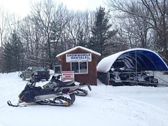
Traverse City Area Featured Snowmobile Rentals
<>Latest Trail Reports – Quick Links
- Ironwood – Western U.P. Trail Report – 12/15
- Sault Ste. Marie Area Trail Report – 12/15
- Newberry Area Trail Report – 12/15
- Gaylord Area Trail Report – 12/15
- Frederic / Gaylord Area Trail Report – Sledheads of Frederic – 12/15
- Traverse City Area Trail Report – 12/14
- Lake Gogebic Area Trail Report – 12/14
- Keweenaw Peninsula Trail Report – 12/14
- Petoskey Area Trail Report – 12/14
- Paradise Area Trail Report – 12/14
- Baldwin Area Trail Report – 12/14
- Sault Ste. Marie Area Trail Report – 12/14
- Grand Marais Area Trail Report – 12/13
- Lake Gogebic Area Trail Report – 12/13
- Newberry Area Trail Report – 12/13
- Cadillac Area Trail Report – 12/13
- Drummond Island Trail Report – 12/13
- Gaylord Area Trail Report – 12/13
- Frederic / Gaylord Area Trail Report – Sledheads of Frederic – 12/13
- Ontonagon Area Trail Report – 12/13
- Harbor Springs Area Trail Report – 12/13
- Seney Area Trail Report – 12/12
- Traverse City Area Trail Report – 12/12
- St. Helen – Roscommon Trail Report – 12/12
- Ontonagon Area Trail Report – 12/12
- Newberry Area Trail Report – 12/12
- Gaylord Area Trail Report – 12/12
- Frederic / Gaylord Area Trail Report – Sledheads of Frederic – 12/12
<>