Frederic / Gaylord Area Trail Report – Sledheads of Frederic – 12/16
There is a light system snow falling right now about 11 on wednesday morning. Forcasts really do not show much if any snow falling between now and saturday but the cold is keeping what snow we do have. I did see the grayling groomer come thru frederic yesterday afternoon but they really cant be doing much more than panning. Keeping what we do have is important to getting our base built up.
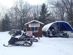
I have spotted only 2 sleds running thru town here this morning. I finally got all the snow moved down at my storage lot so there is still more room for sled trailers if you do not want to haul yours back and forth. Pics below are 2 of my new shirt designs for this year. Hoodies, short sleeve and long sleeve available. Also in wanting to offer my customers the best I tried to pick up some vaccine so I could be the first sled shop in the nation to offer it but they turned me away. It was worth a shot.
Thanks for checking in and its time to keep the snow chant rolling. MO MO NAH CHEE CHEE NAH>………Pete
<>
Visit Sledheads of Frederic Website >>>>
<>
Postings From Regional Pages On Facebook

WEATHER UPDATE via US National Weather Service Gaylord Michigan >> Lake effect snow continues tonight into Sunday as winds shift more northwesterly, shifting focus of snows with time. In addition to the snow, very cold wind chills and air temperatures are expected tonight, particularly in areas away from lake effect snowfall. #miweather #gaylord #cadillac #benzie #traversecity #petoskey

WOLVERINE - GAYLORD AREA UPDATE via The Thirsty Sturgeon >> 8 inches of Freshy Fresh this morning…Lookin’ great out there!! #gaylord #snowphotos
WEATHER UPDATE via US National Weather Service Gaylord Michigan >> Accumulating lake effect snow continues across northern Michigan today into Sunday. Gusty winds will lead to blowing and drifting snow, leading to quick drops in visibility – especially across open areas. Wind chills look to stay below zero today into tonight. Cold temperatures may also lead to freezing of wet roads this morning, contributing to potentially hazardous travel conditions for the first half of the weekend. #miweather #gaylord #cadillac #benzie #traversecity #petoskeyAccumulating lake effect snow continues across northern Michigan today into Sunday. Gusty winds will lead to blowing and drifting snow, leading to quick drops in visibility – especially across open areas. Wind chills look to stay below zero today into tonight. Cold temperatures may also lead to freezing of wet roads this morning, contributing to potentially hazardous travel conditions for the first half of the weekend.
FREDERIC - GAYLORD AREA UPDATE via Sledheads of Frederic , Michigan Snowmobiling >> Friday riders were out but certainly no big crowds, light sled traffic. I see 6 sleds over at the swamp right now and am sure they are there for the breakfast buffet. My gut feeling is its gonna be a slow saturday but conditions are still better than we have seen in years. Had dinner at the Frederic Inn last night and 3 of us had the prime rib and it was great as usual. Left overs for lunch today. Pics below are all from yesterday and last night. Thanks for checking in. Pete #gaylord #snowphotos
Light lake effect overnight, about 1 inch of new fluff
frederic-mi.com
Friday riders were out but certainly no big crowds, light sled traffic. I see 6 sleds over at the swamp right now and am sure they are there for the breakfast buffet. My gut feeling is its gonna be… WEATHER UPDATE via US National Weather Service Gaylord Michigan >> Accumulating snow returns to the Northwoods later this afternoon into Saturday as a cold front swings across the area, ushering in a much colder air mass for the weekend. Several inches of snow is expected across parts of northwest lower and the eastern U.P. by Saturday morning with additional lake effect snow continuing through Saturday. Below zero wind chills are expected for most areas late tonight through Saturday. Wind gusts of 25-35+ mph will lead to patchy blowing/drifting snow, especially across open areas. Quickly dropping temps tonight may freeze wet roads by Saturday morning. Combination of snow, winds, and temperatures will lead to hazardous travel conditions across parts of the area through Saturday morning. #miweather #gaylord #cadillac #benzie #traversecity #petoskeyAccumulating snow returns to the Northwoods later this afternoon into Saturday as a cold front swings across the area, ushering in a much colder air mass for the weekend. Several inches of snow is expected across parts of northwest lower and the eastern U.P. by Saturday morning with additional lake effect snow continuing through Saturday. Below zero wind chills are expected for most areas late tonight through Saturday. Wind gusts of 25-35+ mph will lead to patchy blowing/drifting snow, especially across open areas. Quickly dropping temps tonight may freeze wet roads by Saturday morning. Combination of snow, winds, and temperatures will lead to hazardous travel conditions across parts of the area through Saturday morning.
ST. HELEN AREA UPDATE via St. Helen Snowpackers Snowmobile & ORV Club >> **SNOWMOBILE TRAIL UPDATE**
We are in pretty good shape considering it’s mid-December.
Plenty of snow on the trails.
The base is building but, going easy on the throttle will help keep it in place
A little snirty and thin in some areas, mostly corners.
Get out and ride!
Have Fun! Be Safe! Stay Right! -SEN #sthelen #gaylord
WEATHER UPDATE via US National Weather Service Gaylord Michigan >> Accumulating snow returns to the Northwoods later this afternoon into Saturday as a cold front swings across the area, ushering in a much colder air mass for the weekend. Several inches of snow is expected across parts of northwest lower and the eastern U.P. by Saturday morning with additional lake effect snow continuing through Saturday. Below zero wind chills are expected for most areas late tonight through Saturday. Wind gusts of 25-35+ mph will lead to patchy blowing/drifting snow, especially across open areas. Quickly dropping temps tonight may freeze wet roads by Saturday morning. Combination of snow, winds, and temperatures will lead to hazardous travel conditions across parts of the area through Saturday morning. #miweather #gaylord #cadillac #benzie #traversecity #petoskey #soo #newberryAccumulating snow returns to the Northwoods later this afternoon into Saturday as a cold front swings across the area, ushering in a much colder air mass for the weekend. Several inches of snow is expected across parts of northwest lower and the eastern U.P. by Saturday morning with additional lake effect snow continuing through Saturday. Below zero wind chills are expected for most areas late tonight through Saturday. Wind gusts of 25-35+ mph will lead to patchy blowing/drifting snow, especially across open areas. Quickly dropping temps tonight may freeze wet roads by Saturday morning. Combination of snow, winds, and temperatures will lead to hazardous travel conditions across parts of the area through Saturday morning.
WEATHER UPDATE via Michigan Storm Chasers >> The switch is being flipped into the "on" position for lake effect snow this weekend. Much of what you see won't fall today, but as our extremely cold air mass pushes in late tonight, flurries will begin to fly. Much of the higher totals begin beyond 8 pm EST tonight. Lakeshore areas should prepare for travel delays primarily after this time beginning tonight. Heavy lake effect snow will continue on Saturday thanks to a west-northwest wind, which hints at a shift to out of the northwest by Sunday.
There are concerns with dry air, however the favorable zone for dendrites (snowflakes) to form is essentially on the ground with how cold it'll be. Air temperatures on Saturday alone in the UP may just barely be in the positive single-digits. Wind gusts this weekend may jump to 30-35 mph too, so some of this lake effect snow will push further inland. Totals of 1-3" & 2-6" is a safe bet for much of west and southwest Michigan. Some places may jump above 6" where the heaviest of banding sets up. Further north, our typically higher terrain in the Gaylord region will likely see snowfall totals over 6". Into the UP, much cooler temperatures exist here, and snowfall rates may exceed 1" per hour at times. Totals closer to the one foot mark are likely. The western UP does exhibit a decent chance at totals crossing into the 12-24" category. At the current time, totals are leaning on the lower end of the 12-24" category, but those hotspots where microclimate factors come into play could easily push the upper-bounds of this category. SE Michigan... life carries on once more. Being so far away from the lake effect zones, it's expected that you all will get an inch at most. Isolated hotspots of 1-2" are possible, but don't get your hopes up unless you're close to the Ohio border.
Why 1-3" at the border? Well, we do have a clipper passing to our south Saturday, hence the added 1-3" zone that runs along the MI/IN/OH border. Stay tuned here at MSC for updates this weekend on the lake effect snow AND cold that's set to impact us through Monday. #miweather #keweenaw #westernup #marquette #munising #seney #newberry #soo #straitsarea #gaylord #cadillac #benzie #traversecity #petoskeyThe switch is being flipped into the "on" position for lake effect snow this weekend. Much of what you see won't fall today, but as our extremely cold air mass pushes in late tonight, flurries will begin to fly. Much of the higher totals begin beyond 8 pm EST tonight. Lakeshore areas should prepare for travel delays primarily after this time beginning tonight. Heavy lake effect snow will continue on Saturday thanks to a west-northwest wind, which hints at a shift to out of the northwest by Sunday.
There are concerns with dry air, however the favorable zone for dendrites (snowflakes) to form is essentially on the ground with how cold it'll be. Air temperatures on Saturday alone in the UP may just barely be in the positive single-digits. Wind gusts this weekend may jump to 30-35 mph too, so some of this lake effect snow will push further inland. Totals of 1-3" & 2-6" is a safe bet for much of west and southwest Michigan. Some places may jump above 6" where the heaviest of banding sets up. Further north, our typically higher terrain in the Gaylord region will likely see snowfall totals over 6". Into the UP, much cooler temperatures exist here, and snowfall rates may exceed 1" per hour at times. Totals closer to the one foot mark are likely. The western UP does exhibit a decent chance at totals crossing into the 12-24" category. At the current time, totals are leaning on the lower end of the 12-24" category, but those hotspots where microclimate factors come into play could easily push the upper-bounds of this category. SE Michigan... life carries on once more. Being so far away from the lake effect zones, it's expected that you all will get an inch at most. Isolated hotspots of 1-2" are possible, but don't get your hopes up unless you're close to the Ohio border.
Why 1-3" at the border? Well, we do have a clipper passing to our south Saturday, hence the added 1-3" zone that runs along the MI/IN/OH border. Stay tuned here at MSC for updates this weekend on the lake effect snow AND cold that's set to impact us through Monday.
-- Trusted Partner of the Day --
McKay Tree Specialists | 248-308-7308, call today for all your tree care needs in SE Michigan!
FREDERIC - GAYLORD AREA UPDATE via Sledheads of Frederic , Michigan Snowmobiling >> No new snow overnight. 25 degrees on a cloudy friday morning in downtown Frederic. Just had a group of guys ride in from down around Dayton OHio. They rode to the bridge yesterday. Picture below is of them outside here at Sledheads this morning. Another clipper supposed to come tonight. So we are set on snow and sled traffic has still been slow still. Lets see how it goes this weekend. Here is a video we made years ago. youtu.be/luoEuA9DzqQ?si=jDZlpzDlwjiup8f7
Thanks for checking in. Pete #gaylord #snowphotos
frederic-mi.com
No new snow overnight. 25 degrees on a cloudy friday morning in downtown Frederic. Just had a group of guys ride in from down around Dayton OHio. They rode to the bridge yesterday. Picture below is… Load more
WEATHER UPDATE via US National Weather Service Gaylord Michigan >> Lake effect snow continues tonight into Sunday as winds shift more northwesterly, shifting focus of snows with time. In addition to the snow, very cold wind chills and air temperatures are expected tonight, particularly in areas away from lake effect snowfall. #miweather #gaylord #cadillac #benzie #traversecity #petoskey
WOLVERINE - GAYLORD AREA UPDATE via The Thirsty Sturgeon >> 8 inches of Freshy Fresh this morning…Lookin’ great out there!! #gaylord #snowphotos
WEATHER UPDATE via US National Weather Service Gaylord Michigan >> Accumulating lake effect snow continues across northern Michigan today into Sunday. Gusty winds will lead to blowing and drifting snow, leading to quick drops in visibility – especially across open areas. Wind chills look to stay below zero today into tonight. Cold temperatures may also lead to freezing of wet roads this morning, contributing to potentially hazardous travel conditions for the first half of the weekend. #miweather #gaylord #cadillac #benzie #traversecity #petoskeyAccumulating lake effect snow continues across northern Michigan today into Sunday. Gusty winds will lead to blowing and drifting snow, leading to quick drops in visibility – especially across open areas. Wind chills look to stay below zero today into tonight. Cold temperatures may also lead to freezing of wet roads this morning, contributing to potentially hazardous travel conditions for the first half of the weekend.
FREDERIC - GAYLORD AREA UPDATE via Sledheads of Frederic , Michigan Snowmobiling >> Friday riders were out but certainly no big crowds, light sled traffic. I see 6 sleds over at the swamp right now and am sure they are there for the breakfast buffet. My gut feeling is its gonna be a slow saturday but conditions are still better than we have seen in years. Had dinner at the Frederic Inn last night and 3 of us had the prime rib and it was great as usual. Left overs for lunch today. Pics below are all from yesterday and last night. Thanks for checking in. Pete #gaylord #snowphotos
Light lake effect overnight, about 1 inch of new fluff
frederic-mi.com
Friday riders were out but certainly no big crowds, light sled traffic. I see 6 sleds over at the swamp right now and am sure they are there for the breakfast buffet. My gut feeling is its gonna be…WEATHER UPDATE via US National Weather Service Gaylord Michigan >> Accumulating snow returns to the Northwoods later this afternoon into Saturday as a cold front swings across the area, ushering in a much colder air mass for the weekend. Several inches of snow is expected across parts of northwest lower and the eastern U.P. by Saturday morning with additional lake effect snow continuing through Saturday. Below zero wind chills are expected for most areas late tonight through Saturday. Wind gusts of 25-35+ mph will lead to patchy blowing/drifting snow, especially across open areas. Quickly dropping temps tonight may freeze wet roads by Saturday morning. Combination of snow, winds, and temperatures will lead to hazardous travel conditions across parts of the area through Saturday morning. #miweather #gaylord #cadillac #benzie #traversecity #petoskeyAccumulating snow returns to the Northwoods later this afternoon into Saturday as a cold front swings across the area, ushering in a much colder air mass for the weekend. Several inches of snow is expected across parts of northwest lower and the eastern U.P. by Saturday morning with additional lake effect snow continuing through Saturday. Below zero wind chills are expected for most areas late tonight through Saturday. Wind gusts of 25-35+ mph will lead to patchy blowing/drifting snow, especially across open areas. Quickly dropping temps tonight may freeze wet roads by Saturday morning. Combination of snow, winds, and temperatures will lead to hazardous travel conditions across parts of the area through Saturday morning.
ST. HELEN AREA UPDATE via St. Helen Snowpackers Snowmobile & ORV Club >> **SNOWMOBILE TRAIL UPDATE**
We are in pretty good shape considering it’s mid-December.
Plenty of snow on the trails.
The base is building but, going easy on the throttle will help keep it in place
A little snirty and thin in some areas, mostly corners.
Get out and ride!
Have Fun! Be Safe! Stay Right! -SEN #sthelen #gaylord
WEATHER UPDATE via US National Weather Service Gaylord Michigan >> Accumulating snow returns to the Northwoods later this afternoon into Saturday as a cold front swings across the area, ushering in a much colder air mass for the weekend. Several inches of snow is expected across parts of northwest lower and the eastern U.P. by Saturday morning with additional lake effect snow continuing through Saturday. Below zero wind chills are expected for most areas late tonight through Saturday. Wind gusts of 25-35+ mph will lead to patchy blowing/drifting snow, especially across open areas. Quickly dropping temps tonight may freeze wet roads by Saturday morning. Combination of snow, winds, and temperatures will lead to hazardous travel conditions across parts of the area through Saturday morning. #miweather #gaylord #cadillac #benzie #traversecity #petoskey #soo #newberryAccumulating snow returns to the Northwoods later this afternoon into Saturday as a cold front swings across the area, ushering in a much colder air mass for the weekend. Several inches of snow is expected across parts of northwest lower and the eastern U.P. by Saturday morning with additional lake effect snow continuing through Saturday. Below zero wind chills are expected for most areas late tonight through Saturday. Wind gusts of 25-35+ mph will lead to patchy blowing/drifting snow, especially across open areas. Quickly dropping temps tonight may freeze wet roads by Saturday morning. Combination of snow, winds, and temperatures will lead to hazardous travel conditions across parts of the area through Saturday morning.
WEATHER UPDATE via Michigan Storm Chasers >> The switch is being flipped into the "on" position for lake effect snow this weekend. Much of what you see won't fall today, but as our extremely cold air mass pushes in late tonight, flurries will begin to fly. Much of the higher totals begin beyond 8 pm EST tonight. Lakeshore areas should prepare for travel delays primarily after this time beginning tonight. Heavy lake effect snow will continue on Saturday thanks to a west-northwest wind, which hints at a shift to out of the northwest by Sunday.
There are concerns with dry air, however the favorable zone for dendrites (snowflakes) to form is essentially on the ground with how cold it'll be. Air temperatures on Saturday alone in the UP may just barely be in the positive single-digits. Wind gusts this weekend may jump to 30-35 mph too, so some of this lake effect snow will push further inland. Totals of 1-3" & 2-6" is a safe bet for much of west and southwest Michigan. Some places may jump above 6" where the heaviest of banding sets up. Further north, our typically higher terrain in the Gaylord region will likely see snowfall totals over 6". Into the UP, much cooler temperatures exist here, and snowfall rates may exceed 1" per hour at times. Totals closer to the one foot mark are likely. The western UP does exhibit a decent chance at totals crossing into the 12-24" category. At the current time, totals are leaning on the lower end of the 12-24" category, but those hotspots where microclimate factors come into play could easily push the upper-bounds of this category. SE Michigan... life carries on once more. Being so far away from the lake effect zones, it's expected that you all will get an inch at most. Isolated hotspots of 1-2" are possible, but don't get your hopes up unless you're close to the Ohio border.
Why 1-3" at the border? Well, we do have a clipper passing to our south Saturday, hence the added 1-3" zone that runs along the MI/IN/OH border. Stay tuned here at MSC for updates this weekend on the lake effect snow AND cold that's set to impact us through Monday. #miweather #keweenaw #westernup #marquette #munising #seney #newberry #soo #straitsarea #gaylord #cadillac #benzie #traversecity #petoskeyThe switch is being flipped into the "on" position for lake effect snow this weekend. Much of what you see won't fall today, but as our extremely cold air mass pushes in late tonight, flurries will begin to fly. Much of the higher totals begin beyond 8 pm EST tonight. Lakeshore areas should prepare for travel delays primarily after this time beginning tonight. Heavy lake effect snow will continue on Saturday thanks to a west-northwest wind, which hints at a shift to out of the northwest by Sunday.
There are concerns with dry air, however the favorable zone for dendrites (snowflakes) to form is essentially on the ground with how cold it'll be. Air temperatures on Saturday alone in the UP may just barely be in the positive single-digits. Wind gusts this weekend may jump to 30-35 mph too, so some of this lake effect snow will push further inland. Totals of 1-3" & 2-6" is a safe bet for much of west and southwest Michigan. Some places may jump above 6" where the heaviest of banding sets up. Further north, our typically higher terrain in the Gaylord region will likely see snowfall totals over 6". Into the UP, much cooler temperatures exist here, and snowfall rates may exceed 1" per hour at times. Totals closer to the one foot mark are likely. The western UP does exhibit a decent chance at totals crossing into the 12-24" category. At the current time, totals are leaning on the lower end of the 12-24" category, but those hotspots where microclimate factors come into play could easily push the upper-bounds of this category. SE Michigan... life carries on once more. Being so far away from the lake effect zones, it's expected that you all will get an inch at most. Isolated hotspots of 1-2" are possible, but don't get your hopes up unless you're close to the Ohio border.
Why 1-3" at the border? Well, we do have a clipper passing to our south Saturday, hence the added 1-3" zone that runs along the MI/IN/OH border. Stay tuned here at MSC for updates this weekend on the lake effect snow AND cold that's set to impact us through Monday.
-- Trusted Partner of the Day --
McKay Tree Specialists | 248-308-7308, call today for all your tree care needs in SE Michigan!
FREDERIC - GAYLORD AREA UPDATE via Sledheads of Frederic , Michigan Snowmobiling >> No new snow overnight. 25 degrees on a cloudy friday morning in downtown Frederic. Just had a group of guys ride in from down around Dayton OHio. They rode to the bridge yesterday. Picture below is of them outside here at Sledheads this morning. Another clipper supposed to come tonight. So we are set on snow and sled traffic has still been slow still. Lets see how it goes this weekend. Here is a video we made years ago. youtu.be/luoEuA9DzqQ?si=jDZlpzDlwjiup8f7
Thanks for checking in. Pete #gaylord #snowphotos
frederic-mi.com
No new snow overnight. 25 degrees on a cloudy friday morning in downtown Frederic. Just had a group of guys ride in from down around Dayton OHio. They rode to the bridge yesterday. Picture below is…<>
Visit Sledheads of Frederic Website >>>>
<>
Latest Trail Reports – Quick Links
- Petoskey Area Trail Report – 12/13
- Grand Marais Area Trail Report – 12/13
- Lake Gogebic Area Trail Report – 12/13
- Newberry Area Trail Report – 12/13
- Keweenaw Peninsula Trail Report – 12/13
- Sault Ste. Marie Area Trail Report – 12/13
- Cadillac Area Trail Report – 12/13
- Drummond Island Trail Report – 12/13
- Gaylord Area Trail Report – 12/13
- Frederic / Gaylord Area Trail Report – Sledheads of Frederic – 12/13
- Ontonagon Area Trail Report – 12/13
- Harbor Springs Area Trail Report – 12/13
- Seney Area Trail Report – 12/12
- Traverse City Area Trail Report – 12/12
- St. Helen – Roscommon Trail Report – 12/12
- Ontonagon Area Trail Report – 12/12
- Newberry Area Trail Report – 12/12
- Gaylord Area Trail Report – 12/12
- Frederic / Gaylord Area Trail Report – Sledheads of Frederic – 12/12
- Petoskey Area Trail Report – 12/11
- Munising Area Trail Report – 12/11
- Watersmeet – Western U.P. Trail Report – 12/11
- Baldwin Area Trail Report – 12/11
- Lake Gogebic Area Trail Report – 12/11
- Benzie Area Trail Report – 12/11
- Sidnaw – Western U.P. Trail Report – 12/11
- Frederic / Gaylord Area Trail Report – Sledheads of Frederic – 12/11
- Gaylord Area Trail Report – 12/10
<>