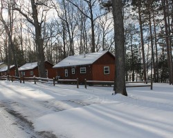
Paradise Area Trail Report – 02/06
February 6, 2023
19 degrees this morning and cloudy. We`ve picked up an inch of snow here an there over the last few days. Sorry I haven`t given ya`ll an update since the 1st, I didn`t realize its been that long! I`ve been very busy now that the weather has cooperated.
There really isn`t anything new to report. The weather has been fantastic and so has the trails!! We are runnin the machines full time and they are runnin great! Every trail is in great shape. Or little comic groomer, Mike H., even came up with a new term for how good the trails are but I told him I still can`t print that.
I`m sure you`ve all seen the weather forecast for the next few days, it doesn`t look too promising with temps approaching the 40`s but the bright side is it looks like they will drop off at night into the 20`s and "they" called off the rain part. The trails might take a beating if the sun comes out cause the snow pack is unusually low but we`ll just have to wait and see. I`ll be on here more often to keep ya`ll informed.
Thats all I have for today. Keep checking back and I`ll keep you up to date on the weather situation.
Remember…..RIDE RIGHT……RIDE SAFE…..You are not the only one on the trail. ALSO, watch out for groomers. We have been hit a couple times this year. We run during the day and night!!!!
LET `ER SNOW!!!!!!!!!!!!!!!!!!!!!………………..and please not get too warm
Groomer Chris
<>
<>
Visit Paradise Area Night Riders on Facebook >>>>
<>
Postings From Regional Pages On Facebook

GRAND MARAIS AREA UPDATE via Grand Marais Sno-Trails Assoc. >> A view of last night’s groom. South route is really looking good after the warm up last week and even Hope says Cool ride on 😎 #grandmarais #newberry #snowphotos
PARADISE AREA UPDATE via Paradise Area Night Riders www.paradiseareanightriders.org >> 1/15/26
2 degrees this morning with a weird freezing fog/misty snow mix in the air. Everything is all white outside....really pretty. After enduring a few days and nights above freezing we finally got the break we needed from Mother Nature and it looks like its gonna stick around for quite a while!!! So here`s our plan......
We are running the Stump trail and the Point trails today but are gonna skip the far north section of the Point trail to let it freeze up more. Tomorrow we are heading south with 2 machines w/o drags and see if we can fix the water holes that opened up on the power line and in the Federal Forest, then Saturday run the high ground trails again and Sunday head to the Falls trail and see what we got. If all goes well hit the swamp south of town on Monday. Gonna be REAL busy for a while. I think we will need more help from Mother Nature with some snow but by next week we should be in better shape. Wish us luck!!!!
LET `ER SNOW!!!!!!!!!!!!!!!!!!!!!!!!!!!!
Groomer Chris #paradise #newberry
NEWBERRY AREA UPDATE via TASA Tahquamenon Area Snowmobile Association >> On trail 45 coming back from the falls toward Newberry ... #newberry #snowphotos
NEWBERRY AREA UPDATE via TASA Tahquamenon Area Snowmobile Association >> Trail Update 01/14/2026
All 3 groomers are out. Trail 45 to the Upper Falls is looking good. Trail 9 is getting into shape and the South trail is great. Ride Safe and always ride right. #newberry
GRAND MARAIS AREA UPDATE via Grand Marais Tavern >> Blustery weather but that doesn’t stop the fun!! #grandmarais #newberry #snowphotos

NEWBERRY AREA UPDATE via Pine Stump >> 1-14-26
11 degrees this morning with a high of 15. This should get everything froze back up
A few inches of snow in the night and it’s still snowing
It looks like the cold and snow will be hanging around now. Second half of the month looks cold now
It should be a good weekend coming up and next week as well!! #newberry #snowphotos
NEWBERRY AREA UPDATE via TASA Tahquamenon Area Snowmobile Association >> Alright, Back to work!
Small delay just past Silver Creek.
In and out of Windy Corners 7:01AM
Pretty lonely up there at that hour.
So here's the scoop after 17.6 miles.
We're still dealing with Sugar Snow, only this Sugar Snow has gotten moist, dried, and its like we had to beat the bejeebers out of it on the counter, and then poured it down the trail.
I can move it where we need it, I can make it flat, I can't make it real pretty, its crusty, looks like sponge surface.
Keeps snowing and blowing like its been since I left, we get her flat on the way up, blend that in on the way back, may get pretty yet! 😊
Two sister water spots mile out from M123 were frozen solid, broke through the end of one and bit, and tried to scrape it a little more to ease the edge some.
Forgot, if you love drifts, you'll love today! It's also packing down very hard, a great new base to work with.
Just turned north to Pine Stump, if you're headed down, I'll see you soon 😊
Made it to Seney T, no signs of life anywhere on this trip so far, 9:23am #newberry #snowphotos
WEATHER UPDATE via Michigan Storm Chasers >> Here is your final look at snowfall totals over a 36-hour period from tonight, through midday Thursday, January 14th through 15th, 2026. NOTE, snow will start overnight for the UP, but later tomorrow morning into the afternoon for the LP.
Discussion
Lake effect snow is the rave with this one. Winds almost directly out of the north coupled with low-level DGZ and strong forcing will allow for many of the areas in dark blue, and especially pink pick up well over half a foot of fresh snow with this event. Hyper-localized banding is expected, which is when the span of 20 miles sees a difference in snow accumulation of 1", to perhaps 12-18". A 1° change in wind direction will help, or hurt your chances at significant snowfall if you're right along the lakeshore areas, especially SW Michigan.
Inland areas will only see under an inch within an initial snow squall and light lake effect afterward. We are not confident that the stretch from Lansing to Port Huron will get more than 1.5", but we put 1-3" just in case. Lake Huron will also show off lake effect snow, with parts of Huron county seeing 4-8". To the north, northwest lower Michigan will see 2-5" and 4-8", with a localized swath of 6"+ near Manistee and points surrounding. Lastly, the UP will see its highest totals along the higher elevation areas of the central portion of the peninsula.
Wind gusts up to 30 mph, even 40-45 mph are likely with this snow, and as a result, near-zero visibilities and drifted roads may occur near each lakeshore. Allow extra travel time when driving on Wednesday in the 4-8", or 6-12"/6-18" zones. We will have radar, weather camera, and traffic updates coming tomorrow as the snow comes down, so drop a follow here at Michigan Storm Chasers for coverage. #miweather #keweenaw #westernup #marquette #munising #seney #newberry #soo #straitsarea #gaylord #cadillac #benzie #traversecity #petoskeyHere is your final look at snowfall totals over a 36-hour period from tonight, through midday Thursday, January 14th through 15th, 2026. NOTE, snow will start overnight for the UP, but later tomorrow morning into the afternoon for the LP.
Discussion
Lake effect snow is the rave with this one. Winds almost directly out of the north coupled with low-level DGZ and strong forcing will allow for many of the areas in dark blue, and especially pink pick up well over half a foot of fresh snow with this event. Hyper-localized banding is expected, which is when the span of 20 miles sees a difference in snow accumulation of 1", to perhaps 12-18". A 1° change in wind direction will help, or hurt your chances at significant snowfall if you're right along the lakeshore areas, especially SW Michigan.
Inland areas will only see under an inch within an initial snow squall and light lake effect afterward. We are not confident that the stretch from Lansing to Port Huron will get more than 1.5", but we put 1-3" just in case. Lake Huron will also show off lake effect snow, with parts of Huron county seeing 4-8". To the north, northwest lower Michigan will see 2-5" and 4-8", with a localized swath of 6"+ near Manistee and points surrounding. Lastly, the UP will see its highest totals along the higher elevation areas of the central portion of the peninsula.
Wind gusts up to 30 mph, even 40-45 mph are likely with this snow, and as a result, near-zero visibilities and drifted roads may occur near each lakeshore. Allow extra travel time when driving on Wednesday in the 4-8", or 6-12"/6-18" zones. We will have radar, weather camera, and traffic updates coming tomorrow as the snow comes down, so drop a follow here at Michigan Storm Chasers for coverage.
-- Trusted Partner on Wednesday --
Top Gun Roofing & Exteriors | 616-900-8033, call today for all exterior home needs across the Grand Rapids area!
WEATHER UPDATE via Meteorologist Brad Sugden >> SNOW TIME!! Lake effect areas, you're about to be buried in some locations! This is purely lake effect that kicks in Wednesday morning and lasts through Thursday afternoon. Thursday afternoon the lake effect subsides as another clipper system moves in.
Temperatures are warmest Wednesday morning then drop significantly into the late afternoon and evening. Many will have wind chills below zero.
Snow will be fluffy and BLOWING. Gusts near 40mph can be expected. #miweather #keweenaw #westernup #munising #newberry #soo #gaylord #cadillac #benzie #traversecity #petoskey
NEWBERRY AREA UPDATE via Trails End Lodging >> The snow is once again falling in Windy Corners! #newberry #snowphotos
WEATHER UPDATE via Michigan Storm Chasers >> Two forecasts for today, January 13th, 2026, and Wednesday, January 14th, 2026, regarding system snow, then lake effect snow.
Graphic #1
A clipper moves through today, bringing rain/freezing drizzle to portions of northern Michigan and the UP, especially north of M-55, with some light rain as far south as I-94. This will change over to a rain/snow mix later this afternoon and evening. Brief accumulation amounts will generally be in the T-1" range, although a couple spots could exceed 1", which are areas highlighted by the 1-3" zone. Air temperatures today will generally be at or above freezing in the UP, but evaporative cooling will still keep the ground cooler than the air.
Graphic #2
Lake effect snow ramps up beyond midnight tonight, heading into tomorrow, the 14th. Early indications are that the central UP will see the most with flow directly out of the north. Areas of 2-5" and 4-8" have been displayed as a result for much of the Lake Superior shoreline region to account for this flow. The LP is still a little on the uncertain side for overachievers tomorrow. We are watching the usual Gaylord region, but also immediate shoreline areas of Lake Michigan from Traverse City down to New Buffalo, and the thumb, as continued flow out of the north seems like on Thursday. For now, totals will remain as shown, and our last call for tomorrow will be out early in the morning. Inland areas in the T-1" zone may also see slight improvements if balloon launch data today continues to trend in the right direction.
Timing for both days is for the entirety of both days, as precipitation will be on-and-off throughout the next 48 hours. Travel concerns will generally be on the mild side of things, but don't let that fool you. Drive with care no matter what's falling out there. Follow us here at Michigan Storm Chasers for updates throughout the next couple days as the snow falls. #miweather #keweenaw #westernup #munising #newberry #soo #gaylord
NEWBERRY AREA UPDATE via Trails End Lodging >> Good morning from Windy Corners! The wind 🌬️ is blowing and the snow ❄️ is falling!
Where is your day taking you?
It would be a great day for a ride to Windy Corners! Stop into WOLF INN Grill & Spirits for a hot meal and top off at North Store Follow Me Outfitters!
Where ever your day takes you… Ride Safe. Ride Right. #newberry #snowphotos
WEATHER UPDATE via Pictured Rocks Marine Weather Conditions >> Here's the updated 3-day snowfall forecast through 7am Friday morning. This includes some system snow today, then lake-effect snow starting tonight and lasting into Thursday morning, followed by more system snow late Thursday into Friday. Temperatures will be relatively warm today, but will plummet overnight tonight. Back to winter! #miweather #keweenaw #westernup #marquette #munising #seney #newberry #soo #straitsarea
This content isn't available right now
When this happens, it's usually because the owner only shared it with a small group of people, changed who can see it or it's been deleted. WEATHER UPDATE via US National Weather Service Marquette Michigan >> #miweather #keweenaw #westernup #marquette #munising #seney #newberry #soo #straitsarea
Load more
GRAND MARAIS AREA UPDATE via Grand Marais Sno-Trails Assoc. >> A view of last night’s groom. South route is really looking good after the warm up last week and even Hope says Cool ride on 😎 #grandmarais #newberry #snowphotos
PARADISE AREA UPDATE via Paradise Area Night Riders www.paradiseareanightriders.org >> 1/15/26
2 degrees this morning with a weird freezing fog/misty snow mix in the air. Everything is all white outside....really pretty. After enduring a few days and nights above freezing we finally got the break we needed from Mother Nature and it looks like its gonna stick around for quite a while!!! So here`s our plan......
We are running the Stump trail and the Point trails today but are gonna skip the far north section of the Point trail to let it freeze up more. Tomorrow we are heading south with 2 machines w/o drags and see if we can fix the water holes that opened up on the power line and in the Federal Forest, then Saturday run the high ground trails again and Sunday head to the Falls trail and see what we got. If all goes well hit the swamp south of town on Monday. Gonna be REAL busy for a while. I think we will need more help from Mother Nature with some snow but by next week we should be in better shape. Wish us luck!!!!
LET `ER SNOW!!!!!!!!!!!!!!!!!!!!!!!!!!!!
Groomer Chris #paradise #newberry
NEWBERRY AREA UPDATE via TASA Tahquamenon Area Snowmobile Association >> On trail 45 coming back from the falls toward Newberry ... #newberry #snowphotos
NEWBERRY AREA UPDATE via TASA Tahquamenon Area Snowmobile Association >> Trail Update 01/14/2026
All 3 groomers are out. Trail 45 to the Upper Falls is looking good. Trail 9 is getting into shape and the South trail is great. Ride Safe and always ride right. #newberry
GRAND MARAIS AREA UPDATE via Grand Marais Tavern >> Blustery weather but that doesn’t stop the fun!! #grandmarais #newberry #snowphotos
NEWBERRY AREA UPDATE via Pine Stump >> 1-14-26
11 degrees this morning with a high of 15. This should get everything froze back up
A few inches of snow in the night and it’s still snowing
It looks like the cold and snow will be hanging around now. Second half of the month looks cold now
It should be a good weekend coming up and next week as well!! #newberry #snowphotos
NEWBERRY AREA UPDATE via TASA Tahquamenon Area Snowmobile Association >> Alright, Back to work!
Small delay just past Silver Creek.
In and out of Windy Corners 7:01AM
Pretty lonely up there at that hour.
So here's the scoop after 17.6 miles.
We're still dealing with Sugar Snow, only this Sugar Snow has gotten moist, dried, and its like we had to beat the bejeebers out of it on the counter, and then poured it down the trail.
I can move it where we need it, I can make it flat, I can't make it real pretty, its crusty, looks like sponge surface.
Keeps snowing and blowing like its been since I left, we get her flat on the way up, blend that in on the way back, may get pretty yet! 😊
Two sister water spots mile out from M123 were frozen solid, broke through the end of one and bit, and tried to scrape it a little more to ease the edge some.
Forgot, if you love drifts, you'll love today! It's also packing down very hard, a great new base to work with.
Just turned north to Pine Stump, if you're headed down, I'll see you soon 😊
Made it to Seney T, no signs of life anywhere on this trip so far, 9:23am #newberry #snowphotos
WEATHER UPDATE via Michigan Storm Chasers >> Here is your final look at snowfall totals over a 36-hour period from tonight, through midday Thursday, January 14th through 15th, 2026. NOTE, snow will start overnight for the UP, but later tomorrow morning into the afternoon for the LP.
Discussion
Lake effect snow is the rave with this one. Winds almost directly out of the north coupled with low-level DGZ and strong forcing will allow for many of the areas in dark blue, and especially pink pick up well over half a foot of fresh snow with this event. Hyper-localized banding is expected, which is when the span of 20 miles sees a difference in snow accumulation of 1", to perhaps 12-18". A 1° change in wind direction will help, or hurt your chances at significant snowfall if you're right along the lakeshore areas, especially SW Michigan.
Inland areas will only see under an inch within an initial snow squall and light lake effect afterward. We are not confident that the stretch from Lansing to Port Huron will get more than 1.5", but we put 1-3" just in case. Lake Huron will also show off lake effect snow, with parts of Huron county seeing 4-8". To the north, northwest lower Michigan will see 2-5" and 4-8", with a localized swath of 6"+ near Manistee and points surrounding. Lastly, the UP will see its highest totals along the higher elevation areas of the central portion of the peninsula.
Wind gusts up to 30 mph, even 40-45 mph are likely with this snow, and as a result, near-zero visibilities and drifted roads may occur near each lakeshore. Allow extra travel time when driving on Wednesday in the 4-8", or 6-12"/6-18" zones. We will have radar, weather camera, and traffic updates coming tomorrow as the snow comes down, so drop a follow here at Michigan Storm Chasers for coverage. #miweather #keweenaw #westernup #marquette #munising #seney #newberry #soo #straitsarea #gaylord #cadillac #benzie #traversecity #petoskeyHere is your final look at snowfall totals over a 36-hour period from tonight, through midday Thursday, January 14th through 15th, 2026. NOTE, snow will start overnight for the UP, but later tomorrow morning into the afternoon for the LP.
Discussion
Lake effect snow is the rave with this one. Winds almost directly out of the north coupled with low-level DGZ and strong forcing will allow for many of the areas in dark blue, and especially pink pick up well over half a foot of fresh snow with this event. Hyper-localized banding is expected, which is when the span of 20 miles sees a difference in snow accumulation of 1", to perhaps 12-18". A 1° change in wind direction will help, or hurt your chances at significant snowfall if you're right along the lakeshore areas, especially SW Michigan.
Inland areas will only see under an inch within an initial snow squall and light lake effect afterward. We are not confident that the stretch from Lansing to Port Huron will get more than 1.5", but we put 1-3" just in case. Lake Huron will also show off lake effect snow, with parts of Huron county seeing 4-8". To the north, northwest lower Michigan will see 2-5" and 4-8", with a localized swath of 6"+ near Manistee and points surrounding. Lastly, the UP will see its highest totals along the higher elevation areas of the central portion of the peninsula.
Wind gusts up to 30 mph, even 40-45 mph are likely with this snow, and as a result, near-zero visibilities and drifted roads may occur near each lakeshore. Allow extra travel time when driving on Wednesday in the 4-8", or 6-12"/6-18" zones. We will have radar, weather camera, and traffic updates coming tomorrow as the snow comes down, so drop a follow here at Michigan Storm Chasers for coverage.
-- Trusted Partner on Wednesday --
Top Gun Roofing & Exteriors | 616-900-8033, call today for all exterior home needs across the Grand Rapids area!
WEATHER UPDATE via Meteorologist Brad Sugden >> SNOW TIME!! Lake effect areas, you're about to be buried in some locations! This is purely lake effect that kicks in Wednesday morning and lasts through Thursday afternoon. Thursday afternoon the lake effect subsides as another clipper system moves in.
Temperatures are warmest Wednesday morning then drop significantly into the late afternoon and evening. Many will have wind chills below zero.
Snow will be fluffy and BLOWING. Gusts near 40mph can be expected. #miweather #keweenaw #westernup #munising #newberry #soo #gaylord #cadillac #benzie #traversecity #petoskey
NEWBERRY AREA UPDATE via Trails End Lodging >> The snow is once again falling in Windy Corners! #newberry #snowphotos
WEATHER UPDATE via Michigan Storm Chasers >> Two forecasts for today, January 13th, 2026, and Wednesday, January 14th, 2026, regarding system snow, then lake effect snow.
Graphic #1
A clipper moves through today, bringing rain/freezing drizzle to portions of northern Michigan and the UP, especially north of M-55, with some light rain as far south as I-94. This will change over to a rain/snow mix later this afternoon and evening. Brief accumulation amounts will generally be in the T-1" range, although a couple spots could exceed 1", which are areas highlighted by the 1-3" zone. Air temperatures today will generally be at or above freezing in the UP, but evaporative cooling will still keep the ground cooler than the air.
Graphic #2
Lake effect snow ramps up beyond midnight tonight, heading into tomorrow, the 14th. Early indications are that the central UP will see the most with flow directly out of the north. Areas of 2-5" and 4-8" have been displayed as a result for much of the Lake Superior shoreline region to account for this flow. The LP is still a little on the uncertain side for overachievers tomorrow. We are watching the usual Gaylord region, but also immediate shoreline areas of Lake Michigan from Traverse City down to New Buffalo, and the thumb, as continued flow out of the north seems like on Thursday. For now, totals will remain as shown, and our last call for tomorrow will be out early in the morning. Inland areas in the T-1" zone may also see slight improvements if balloon launch data today continues to trend in the right direction.
Timing for both days is for the entirety of both days, as precipitation will be on-and-off throughout the next 48 hours. Travel concerns will generally be on the mild side of things, but don't let that fool you. Drive with care no matter what's falling out there. Follow us here at Michigan Storm Chasers for updates throughout the next couple days as the snow falls. #miweather #keweenaw #westernup #munising #newberry #soo #gaylord
NEWBERRY AREA UPDATE via Trails End Lodging >> Good morning from Windy Corners! The wind 🌬️ is blowing and the snow ❄️ is falling!
Where is your day taking you?
It would be a great day for a ride to Windy Corners! Stop into WOLF INN Grill & Spirits for a hot meal and top off at North Store Follow Me Outfitters!
Where ever your day takes you… Ride Safe. Ride Right. #newberry #snowphotos
WEATHER UPDATE via Pictured Rocks Marine Weather Conditions >> Here's the updated 3-day snowfall forecast through 7am Friday morning. This includes some system snow today, then lake-effect snow starting tonight and lasting into Thursday morning, followed by more system snow late Thursday into Friday. Temperatures will be relatively warm today, but will plummet overnight tonight. Back to winter! #miweather #keweenaw #westernup #marquette #munising #seney #newberry #soo #straitsarea
This content isn't available right now
When this happens, it's usually because the owner only shared it with a small group of people, changed who can see it or it's been deleted.WEATHER UPDATE via US National Weather Service Marquette Michigan >> #miweather #keweenaw #westernup #marquette #munising #seney #newberry #soo #straitsarea
<>
Latest Trail Reports – Quick Links
- Gaylord Area Trail Report – 01/15
- Frederic / Gaylord Area Trail Report – Sledheads of Frederic – 01/15
- Watersmeet – Western U.P. Trail Report – 01/15
- Grand Marais Area Trail Report – 01/15
- Keweenaw Peninsula Trail Report – 01/15
- Paradise Area Trail Report – 01/15
- Ontonagon Area Trail Report – 01/15
- Sault Ste. Marie Area Trail Report – 01/14
- Ironwood – Western U.P. Trail Report – 01/14
- Ontonagon Area Trail Report – 01/14
- Munising Area Trail Report – 01/14
- Frederic / Gaylord Area Trail Report – Sledheads of Frederic – 01/14
- Grand Marais Area Trail Report – 01/14
- Gaylord Area Trail Report – 01/14
- Harbor Springs Area Trail Report – 01/14
- Lake Gogebic Trail Report – 01/14
- Sidnaw – Western U.P. Trail Report – 01/14
- Newberry Area Trail Report – 01/14
- Keweenaw Peninsula Trail Report – 01/13
- Watersmeet – Western U.P. Trail Report – 01/13
- Newberry Area Trail Report – 01/13
- Gaylord Area Trail Report – 01/13
- Frederic / Gaylord Area Trail Report – Sledheads of Frederic – 01/13
- Sault Ste. Marie Area Trail Report – 01/13
- Cadillac Area Trail Report – 01/12
- Munising Area Trail Report – 01/12
- Sidnaw – Western U.P. Trail Report – 01/12
- Seney Area Trail Report – 01/12
<>