
Gaylord Area Trail Report – 02/10
Gaylord Bureau –
Feb 10, 2023 – 10:25 a.m.
The weather has been playing tricks on us this week! Our trails were in good condition last weekend, but we experienced a warm up and had some rain throughout the week. We received 5-8 inches of wet, heavy snow over the past 24 hours, so everything is white again. Trails may be slippery under the new cover of snow. Groomers have rated the trails in fair condition, but are unable to run due to warmer temperatures and wet snow. Temperatures are back in the high 30’s and 40’s this weekend and into next week.
As always, check back with us for updates and weather reports.
http://www.gaylordmichigan.net/snowmobile-trail-report-114/
<>
Five new inches of slushy white stuff. The rain finally slowed up about 5 last night and then the snow started. We had a couple inches in Grayling but alot more here in Frederic. Its 10:30 Friday morning and there have been 5 sleds thru here this morning. This is free snowmobiling weekend so you dont need a permit of registration but who cares about that. We have a bit of snow and pushing thru the wet heavy slush will be a challenge but you could get a ride in today. Who knows if it will last thru tommorow as above freezing into the 40s is supposed to be back on saturday. You know its a crap shoot. The pics below are from this mornings riders and they are all excited to be out there. My feeling is if you arent here already and able to ride you will probably miss out. I guess its all part of the new normal. Thanks for checking in. Pete
http://frederic-mi.com/category/trail-conditions/
Postings From Regional Pages On Facebook

WEATHER UPDATE via Michigan Storm Chasers >> Here is your final look at snowfall totals over a 36-hour period from tonight, through midday Thursday, January 14th through 15th, 2026. NOTE, snow will start overnight for the UP, but later tomorrow morning into the afternoon for the LP.
Discussion
Lake effect snow is the rave with this one. Winds almost directly out of the north coupled with low-level DGZ and strong forcing will allow for many of the areas in dark blue, and especially pink pick up well over half a foot of fresh snow with this event. Hyper-localized banding is expected, which is when the span of 20 miles sees a difference in snow accumulation of 1", to perhaps 12-18". A 1° change in wind direction will help, or hurt your chances at significant snowfall if you're right along the lakeshore areas, especially SW Michigan.
Inland areas will only see under an inch within an initial snow squall and light lake effect afterward. We are not confident that the stretch from Lansing to Port Huron will get more than 1.5", but we put 1-3" just in case. Lake Huron will also show off lake effect snow, with parts of Huron county seeing 4-8". To the north, northwest lower Michigan will see 2-5" and 4-8", with a localized swath of 6"+ near Manistee and points surrounding. Lastly, the UP will see its highest totals along the higher elevation areas of the central portion of the peninsula.
Wind gusts up to 30 mph, even 40-45 mph are likely with this snow, and as a result, near-zero visibilities and drifted roads may occur near each lakeshore. Allow extra travel time when driving on Wednesday in the 4-8", or 6-12"/6-18" zones. We will have radar, weather camera, and traffic updates coming tomorrow as the snow comes down, so drop a follow here at Michigan Storm Chasers for coverage. #miweather #keweenaw #westernup #marquette #munising #seney #newberry #soo #straitsarea #gaylord #cadillac #benzie #traversecity #petoskeyHere is your final look at snowfall totals over a 36-hour period from tonight, through midday Thursday, January 14th through 15th, 2026. NOTE, snow will start overnight for the UP, but later tomorrow morning into the afternoon for the LP.
Discussion
Lake effect snow is the rave with this one. Winds almost directly out of the north coupled with low-level DGZ and strong forcing will allow for many of the areas in dark blue, and especially pink pick up well over half a foot of fresh snow with this event. Hyper-localized banding is expected, which is when the span of 20 miles sees a difference in snow accumulation of 1", to perhaps 12-18". A 1° change in wind direction will help, or hurt your chances at significant snowfall if you're right along the lakeshore areas, especially SW Michigan.
Inland areas will only see under an inch within an initial snow squall and light lake effect afterward. We are not confident that the stretch from Lansing to Port Huron will get more than 1.5", but we put 1-3" just in case. Lake Huron will also show off lake effect snow, with parts of Huron county seeing 4-8". To the north, northwest lower Michigan will see 2-5" and 4-8", with a localized swath of 6"+ near Manistee and points surrounding. Lastly, the UP will see its highest totals along the higher elevation areas of the central portion of the peninsula.
Wind gusts up to 30 mph, even 40-45 mph are likely with this snow, and as a result, near-zero visibilities and drifted roads may occur near each lakeshore. Allow extra travel time when driving on Wednesday in the 4-8", or 6-12"/6-18" zones. We will have radar, weather camera, and traffic updates coming tomorrow as the snow comes down, so drop a follow here at Michigan Storm Chasers for coverage.
-- Trusted Partner on Wednesday --
Top Gun Roofing & Exteriors | 616-900-8033, call today for all exterior home needs across the Grand Rapids area!

WEATHER UPDATE via Meteorologist Brad Sugden >> SNOW TIME!! Lake effect areas, you're about to be buried in some locations! This is purely lake effect that kicks in Wednesday morning and lasts through Thursday afternoon. Thursday afternoon the lake effect subsides as another clipper system moves in.
Temperatures are warmest Wednesday morning then drop significantly into the late afternoon and evening. Many will have wind chills below zero.
Snow will be fluffy and BLOWING. Gusts near 40mph can be expected. #miweather #keweenaw #westernup #munising #newberry #soo #gaylord #cadillac #benzie #traversecity #petoskey
WEATHER UPDATE via US National Weather Service Gaylord Michigan>> Lake effect snow spread across northern Michigan tonight through Thursday night. While most areas can expect only an inch or less of accumulations… areas southwest of Grand Traverse Bay will observe 3-5” with locally higher amounts of 8”+. Widespread falling temperatures will impact the entire region with wind chills near/below zero by Wednesday morning. #miweather #gaylord #cadillac #benzie #traversecity #petoskeyLake effect snow spread across northern Michigan tonight through Thursday night. While most areas can expect only an inch or less of accumulations… areas southwest of Grand Traverse Bay will observe 3-5” with locally higher amounts of 8”+. Widespread falling temperatures will impact the entire region with wind chills near/below zero by Wednesday morning.
WEATHER UPDATE via Michigan Storm Chasers >> Two forecasts for today, January 13th, 2026, and Wednesday, January 14th, 2026, regarding system snow, then lake effect snow.
Graphic #1
A clipper moves through today, bringing rain/freezing drizzle to portions of northern Michigan and the UP, especially north of M-55, with some light rain as far south as I-94. This will change over to a rain/snow mix later this afternoon and evening. Brief accumulation amounts will generally be in the T-1" range, although a couple spots could exceed 1", which are areas highlighted by the 1-3" zone. Air temperatures today will generally be at or above freezing in the UP, but evaporative cooling will still keep the ground cooler than the air.
Graphic #2
Lake effect snow ramps up beyond midnight tonight, heading into tomorrow, the 14th. Early indications are that the central UP will see the most with flow directly out of the north. Areas of 2-5" and 4-8" have been displayed as a result for much of the Lake Superior shoreline region to account for this flow. The LP is still a little on the uncertain side for overachievers tomorrow. We are watching the usual Gaylord region, but also immediate shoreline areas of Lake Michigan from Traverse City down to New Buffalo, and the thumb, as continued flow out of the north seems like on Thursday. For now, totals will remain as shown, and our last call for tomorrow will be out early in the morning. Inland areas in the T-1" zone may also see slight improvements if balloon launch data today continues to trend in the right direction.
Timing for both days is for the entirety of both days, as precipitation will be on-and-off throughout the next 48 hours. Travel concerns will generally be on the mild side of things, but don't let that fool you. Drive with care no matter what's falling out there. Follow us here at Michigan Storm Chasers for updates throughout the next couple days as the snow falls. #miweather #keweenaw #westernup #munising #newberry #soo #gaylord
FREDERIC - GAYLORD AREA UPDATE via Sledheads of Frederic , Michigan Snowmobiling >> Its a misty rainy tuesday morning in downtown Frederic at 35 degrees. It made it up to 40 yesterday. The temp is supposed to drop starting tommorow with light snow predicted in the next few days. I am going to go out with my plow and push slush around at the storage lot. I did see some sleds out and about yesterday but none on my side of the road.I wish I had better news. Thanks for checking in. Pete #gaylord #snowphotos
frederic-mi.com
Its a misty rainy tuesday morning in downtown Frederic at 35 degrees. It made it up to 40 yesterday. The temp is supposed to drop starting tommorow with light snow predicted in the next few days. I… WEATHER UPDATE via US National Weather Service Gaylord Michigan >> Times of rain, snow and a rain/snow mix will be seen today for most of northern MI today. Up to 2 inches of wet, slushy snow is possible for parts of eastern upper by this evening. Some spots could see brief freezing rain, however temperatures will rise to above freezing today for most areas. Strong winds, cold temperatures and accumulating snow will be seen late tonight. #miweather #gaylord #cadillac #benzie #traversecity #petoskeyTimes of rain, snow and a rain/snow mix will be seen today for most of northern MI today. Up to 2 inches of wet, slushy snow is possible for parts of eastern upper by this evening. Some spots could see brief freezing rain, however temperatures will rise to above freezing today for most areas. Strong winds, cold temperatures and accumulating snow will be seen late tonight.
FREDERIC - GAYLORD AREA UPDATE via Swamp II Bar & Restaurant in Frederic MI >> Today we had a gentleman call and was wondering how the trails are... we asked 2 snowmobilers and they said actually pretty good, they were coming from Higgins and heading to Gaylord next.... I told the guy I would take some pictures of the trails on my way out and post them. Here is trail7 in front of the Swamp II Bar & Restaurant in Frederic MI and also the trailhead and Trail off 612 in Fredeic...
Weather is always moody, but calling for rain tomorrow and snow every day after! 4 day weekend coming up! #gaylord #snowphotos
I always start in Fredric from sledheads, but trails are always terrible until I get to the kalkaska county line. I'm thinking it's time to ride elsewhere.
Trail 7 from Fredrick to Gaylord is always a mess unless you have a ton of snow to get off of the not groomed trail
WEATHER UPDATE via US National Weather Service Gaylord Michigan >> A return to above normal temperatures will start out our work week. Today and tonight will be mainly quiet. A snow-rain mix is expected on Tuesday, with a light slushy accumulation possible in the morning in eastern upper Michigan. Temperatures will be falling late Tuesday night through the day Wednesday, with brisk northerly winds, along with snow showers and light accumulations. Thursday will be colder but with less snow. #miweather #gaylord #cadillac #benzie #traversecity #petoskeyA return to above normal temperatures will start out our work week. Today and tonight will be mainly quiet. A snow-rain mix is expected on Tuesday, with a light slushy accumulation possible in the morning in eastern upper Michigan. Temperatures will be falling late Tuesday night through the day Wednesday, with brisk northerly winds, along with snow showers and light accumulations. Thursday will be colder but with less snow.
FREDERIC - GAYLORD AREA UPDATE via Sledheads of Frederic , Michigan Snowmobiling >> Its a nice calm monday morning with no new snow. I never put an update out on sunday but we had about 5 inches of new snow late saturday night. It was very quiet around Frederic yesterday as the snow came late but for those that got to ride it it made a pleasant surprise. That is including me. We headed out for a ride about 3 and found alot of great snow and rode over to Lovells and around the air to ground and back. I acutually saw the grayling groomer out but he was coming from behind the high school and turning on to 47 trail. Of course trail 7 still had not been touched and it beat me up again. I sure dont know what the deal is on that... #gaylord #snowphotos
frederic-mi.com
Its a nice calm monday morning with no new snow. I never put an update out on sunday but we had about 5 inches of new snow late saturday night. It was very quiet around Frederic yesterday as the sn… WEATHER UPDATE via US National Weather Service Gaylord Michigan >> After a few light snow showers pass across eastern upper overnight, weather turns pretty mild and quiet this Monday. Mixed rain/snow showers then move across the Great Lakes region this Tuesday and Wednesday followed by very chilly temperatures through the remainder of the work week. #miweather #gaylord #cadillac #benzie #traversecity #petoskeyAfter a few light snow showers pass across eastern upper overnight, weather turns pretty mild and quiet this Monday. Mixed rain/snow showers then move across the Great Lakes region this Tuesday and Wednesday followed by very chilly temperatures through the remainder of the work week.
GAYLORD AREA UPDATE via Town Hall Snowmobile Club Paradise MI >> A little down state riding in Gaylord, Fredrick and Wolverine. Snow started Saturday around 2. We have at least 6-8”. Trails are decent. A little rougher from the melt but more the enough snow to cool a 2” Assault! #gaylord #snowphotos
Load more
WEATHER UPDATE via Michigan Storm Chasers >> Here is your final look at snowfall totals over a 36-hour period from tonight, through midday Thursday, January 14th through 15th, 2026. NOTE, snow will start overnight for the UP, but later tomorrow morning into the afternoon for the LP.
Discussion
Lake effect snow is the rave with this one. Winds almost directly out of the north coupled with low-level DGZ and strong forcing will allow for many of the areas in dark blue, and especially pink pick up well over half a foot of fresh snow with this event. Hyper-localized banding is expected, which is when the span of 20 miles sees a difference in snow accumulation of 1", to perhaps 12-18". A 1° change in wind direction will help, or hurt your chances at significant snowfall if you're right along the lakeshore areas, especially SW Michigan.
Inland areas will only see under an inch within an initial snow squall and light lake effect afterward. We are not confident that the stretch from Lansing to Port Huron will get more than 1.5", but we put 1-3" just in case. Lake Huron will also show off lake effect snow, with parts of Huron county seeing 4-8". To the north, northwest lower Michigan will see 2-5" and 4-8", with a localized swath of 6"+ near Manistee and points surrounding. Lastly, the UP will see its highest totals along the higher elevation areas of the central portion of the peninsula.
Wind gusts up to 30 mph, even 40-45 mph are likely with this snow, and as a result, near-zero visibilities and drifted roads may occur near each lakeshore. Allow extra travel time when driving on Wednesday in the 4-8", or 6-12"/6-18" zones. We will have radar, weather camera, and traffic updates coming tomorrow as the snow comes down, so drop a follow here at Michigan Storm Chasers for coverage. #miweather #keweenaw #westernup #marquette #munising #seney #newberry #soo #straitsarea #gaylord #cadillac #benzie #traversecity #petoskeyHere is your final look at snowfall totals over a 36-hour period from tonight, through midday Thursday, January 14th through 15th, 2026. NOTE, snow will start overnight for the UP, but later tomorrow morning into the afternoon for the LP.
Discussion
Lake effect snow is the rave with this one. Winds almost directly out of the north coupled with low-level DGZ and strong forcing will allow for many of the areas in dark blue, and especially pink pick up well over half a foot of fresh snow with this event. Hyper-localized banding is expected, which is when the span of 20 miles sees a difference in snow accumulation of 1", to perhaps 12-18". A 1° change in wind direction will help, or hurt your chances at significant snowfall if you're right along the lakeshore areas, especially SW Michigan.
Inland areas will only see under an inch within an initial snow squall and light lake effect afterward. We are not confident that the stretch from Lansing to Port Huron will get more than 1.5", but we put 1-3" just in case. Lake Huron will also show off lake effect snow, with parts of Huron county seeing 4-8". To the north, northwest lower Michigan will see 2-5" and 4-8", with a localized swath of 6"+ near Manistee and points surrounding. Lastly, the UP will see its highest totals along the higher elevation areas of the central portion of the peninsula.
Wind gusts up to 30 mph, even 40-45 mph are likely with this snow, and as a result, near-zero visibilities and drifted roads may occur near each lakeshore. Allow extra travel time when driving on Wednesday in the 4-8", or 6-12"/6-18" zones. We will have radar, weather camera, and traffic updates coming tomorrow as the snow comes down, so drop a follow here at Michigan Storm Chasers for coverage.
-- Trusted Partner on Wednesday --
Top Gun Roofing & Exteriors | 616-900-8033, call today for all exterior home needs across the Grand Rapids area!
WEATHER UPDATE via Meteorologist Brad Sugden >> SNOW TIME!! Lake effect areas, you're about to be buried in some locations! This is purely lake effect that kicks in Wednesday morning and lasts through Thursday afternoon. Thursday afternoon the lake effect subsides as another clipper system moves in.
Temperatures are warmest Wednesday morning then drop significantly into the late afternoon and evening. Many will have wind chills below zero.
Snow will be fluffy and BLOWING. Gusts near 40mph can be expected. #miweather #keweenaw #westernup #munising #newberry #soo #gaylord #cadillac #benzie #traversecity #petoskey
WEATHER UPDATE via US National Weather Service Gaylord Michigan>> Lake effect snow spread across northern Michigan tonight through Thursday night. While most areas can expect only an inch or less of accumulations… areas southwest of Grand Traverse Bay will observe 3-5” with locally higher amounts of 8”+. Widespread falling temperatures will impact the entire region with wind chills near/below zero by Wednesday morning. #miweather #gaylord #cadillac #benzie #traversecity #petoskeyLake effect snow spread across northern Michigan tonight through Thursday night. While most areas can expect only an inch or less of accumulations… areas southwest of Grand Traverse Bay will observe 3-5” with locally higher amounts of 8”+. Widespread falling temperatures will impact the entire region with wind chills near/below zero by Wednesday morning.
WEATHER UPDATE via Michigan Storm Chasers >> Two forecasts for today, January 13th, 2026, and Wednesday, January 14th, 2026, regarding system snow, then lake effect snow.
Graphic #1
A clipper moves through today, bringing rain/freezing drizzle to portions of northern Michigan and the UP, especially north of M-55, with some light rain as far south as I-94. This will change over to a rain/snow mix later this afternoon and evening. Brief accumulation amounts will generally be in the T-1" range, although a couple spots could exceed 1", which are areas highlighted by the 1-3" zone. Air temperatures today will generally be at or above freezing in the UP, but evaporative cooling will still keep the ground cooler than the air.
Graphic #2
Lake effect snow ramps up beyond midnight tonight, heading into tomorrow, the 14th. Early indications are that the central UP will see the most with flow directly out of the north. Areas of 2-5" and 4-8" have been displayed as a result for much of the Lake Superior shoreline region to account for this flow. The LP is still a little on the uncertain side for overachievers tomorrow. We are watching the usual Gaylord region, but also immediate shoreline areas of Lake Michigan from Traverse City down to New Buffalo, and the thumb, as continued flow out of the north seems like on Thursday. For now, totals will remain as shown, and our last call for tomorrow will be out early in the morning. Inland areas in the T-1" zone may also see slight improvements if balloon launch data today continues to trend in the right direction.
Timing for both days is for the entirety of both days, as precipitation will be on-and-off throughout the next 48 hours. Travel concerns will generally be on the mild side of things, but don't let that fool you. Drive with care no matter what's falling out there. Follow us here at Michigan Storm Chasers for updates throughout the next couple days as the snow falls. #miweather #keweenaw #westernup #munising #newberry #soo #gaylord
FREDERIC - GAYLORD AREA UPDATE via Sledheads of Frederic , Michigan Snowmobiling >> Its a misty rainy tuesday morning in downtown Frederic at 35 degrees. It made it up to 40 yesterday. The temp is supposed to drop starting tommorow with light snow predicted in the next few days. I am going to go out with my plow and push slush around at the storage lot. I did see some sleds out and about yesterday but none on my side of the road.I wish I had better news. Thanks for checking in. Pete #gaylord #snowphotos
frederic-mi.com
Its a misty rainy tuesday morning in downtown Frederic at 35 degrees. It made it up to 40 yesterday. The temp is supposed to drop starting tommorow with light snow predicted in the next few days. I…WEATHER UPDATE via US National Weather Service Gaylord Michigan >> Times of rain, snow and a rain/snow mix will be seen today for most of northern MI today. Up to 2 inches of wet, slushy snow is possible for parts of eastern upper by this evening. Some spots could see brief freezing rain, however temperatures will rise to above freezing today for most areas. Strong winds, cold temperatures and accumulating snow will be seen late tonight. #miweather #gaylord #cadillac #benzie #traversecity #petoskeyTimes of rain, snow and a rain/snow mix will be seen today for most of northern MI today. Up to 2 inches of wet, slushy snow is possible for parts of eastern upper by this evening. Some spots could see brief freezing rain, however temperatures will rise to above freezing today for most areas. Strong winds, cold temperatures and accumulating snow will be seen late tonight.
FREDERIC - GAYLORD AREA UPDATE via Swamp II Bar & Restaurant in Frederic MI >> Today we had a gentleman call and was wondering how the trails are... we asked 2 snowmobilers and they said actually pretty good, they were coming from Higgins and heading to Gaylord next.... I told the guy I would take some pictures of the trails on my way out and post them. Here is trail7 in front of the Swamp II Bar & Restaurant in Frederic MI and also the trailhead and Trail off 612 in Fredeic...
Weather is always moody, but calling for rain tomorrow and snow every day after! 4 day weekend coming up! #gaylord #snowphotos
I always start in Fredric from sledheads, but trails are always terrible until I get to the kalkaska county line. I'm thinking it's time to ride elsewhere.
Trail 7 from Fredrick to Gaylord is always a mess unless you have a ton of snow to get off of the not groomed trail
WEATHER UPDATE via US National Weather Service Gaylord Michigan >> A return to above normal temperatures will start out our work week. Today and tonight will be mainly quiet. A snow-rain mix is expected on Tuesday, with a light slushy accumulation possible in the morning in eastern upper Michigan. Temperatures will be falling late Tuesday night through the day Wednesday, with brisk northerly winds, along with snow showers and light accumulations. Thursday will be colder but with less snow. #miweather #gaylord #cadillac #benzie #traversecity #petoskeyA return to above normal temperatures will start out our work week. Today and tonight will be mainly quiet. A snow-rain mix is expected on Tuesday, with a light slushy accumulation possible in the morning in eastern upper Michigan. Temperatures will be falling late Tuesday night through the day Wednesday, with brisk northerly winds, along with snow showers and light accumulations. Thursday will be colder but with less snow.
FREDERIC - GAYLORD AREA UPDATE via Sledheads of Frederic , Michigan Snowmobiling >> Its a nice calm monday morning with no new snow. I never put an update out on sunday but we had about 5 inches of new snow late saturday night. It was very quiet around Frederic yesterday as the snow came late but for those that got to ride it it made a pleasant surprise. That is including me. We headed out for a ride about 3 and found alot of great snow and rode over to Lovells and around the air to ground and back. I acutually saw the grayling groomer out but he was coming from behind the high school and turning on to 47 trail. Of course trail 7 still had not been touched and it beat me up again. I sure dont know what the deal is on that... #gaylord #snowphotos
frederic-mi.com
Its a nice calm monday morning with no new snow. I never put an update out on sunday but we had about 5 inches of new snow late saturday night. It was very quiet around Frederic yesterday as the sn…WEATHER UPDATE via US National Weather Service Gaylord Michigan >> After a few light snow showers pass across eastern upper overnight, weather turns pretty mild and quiet this Monday. Mixed rain/snow showers then move across the Great Lakes region this Tuesday and Wednesday followed by very chilly temperatures through the remainder of the work week. #miweather #gaylord #cadillac #benzie #traversecity #petoskeyAfter a few light snow showers pass across eastern upper overnight, weather turns pretty mild and quiet this Monday. Mixed rain/snow showers then move across the Great Lakes region this Tuesday and Wednesday followed by very chilly temperatures through the remainder of the work week.
GAYLORD AREA UPDATE via Town Hall Snowmobile Club Paradise MI >> A little down state riding in Gaylord, Fredrick and Wolverine. Snow started Saturday around 2. We have at least 6-8”. Trails are decent. A little rougher from the melt but more the enough snow to cool a 2” Assault! #gaylord #snowphotos
<>
<>
<>
Gaylord Area Featured Snowmobile Lodging

<>
Gaylord Area Snowmobile Lodging & Services
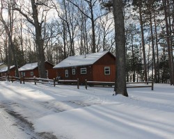
Pine Cone Accommodations – “Check-In and Ride” Snowmobile Lodging – Gaylord
WINTER SPECIALS: Contact our office today to Book Your Stay! (866) 731-1887 The Gaylord Area boasts countless recreational opportunities, be it golf, skiing, hiking, fly fishing, canoeing, or snowmobiling. When you visit our beautiful north country, why not treat yourself to the comfort and relaxation of one of our vacation rental properties. Pine Cone […] more...
The Waters Inn – Gaylord Area
Just off I-75 at Exit 270 on Old US-27, the Waters Inn is The Peaceful Alternative, with access to everything the Gaylord area has to offer, without the traffic, noise and neon. On the snowmobile trail, and a nine iron from dozens of lakes and golf courses.Ten Exclusive Themed Rooms, with in room phones, refrigerators, […] more...
DerMiner’s Parkside Resort – On Snowmobile Trail #7 in Gaylord
A wonderful getaway awaits you at DerMiner’s Parkside Resort in Gaylord. Located on a private road are four (4) beautifully renovated two bedroom cabins nestled between Otsego Lake and snowmobile trail #7. Cabins comfortably sleep 6 – Full size bed, twin bunk beds and a full size sleep sofa. No need to hassle with lugging […] more...
Treetops Resort
5 miles east of Gaylord – 243 newly renovated accommodations, including standard rooms, deluxe suites, condominiums and resort homes. Two indoor / two outdoor pools with spas, two restaurants, sports bar, weekend prime rib buffets, over 20,000 sq. ft. of meeting and banquet space, 81 holes of championship golf including designs by Robert Trent Jones, […] more...
DerMiner’s Parkside Market Snowmobile Rentals
Snowmobile Rental for the Northern Lower Peninsula of Michigan at DerMiners Parkside Market in Gaylord, Michigan. F 5 LXR Liquid Cooled – Single person snowmobile. ARCTIC CAT T570, 2-Person Snowmobile. Complete Snowmobile Outfitter – Rental helmets, snowmobile suits, and trailers are also available Try the awesome F-5 LXR Liquid Cooled snowmobile or the ARCTIC CAT T- […] more...
Snow Photos From Gaylord – Ray’s Retreat
Snow and more snow! Woke up this morning to another 4-5 inches of fresh snow. Snow continued thru the day, at least another 6 inches of new stop. It just doesn’t stop! At least a foot and a half or more of snow. The Winter Storm Warning is now continued thru Friday evening. Lake Effect […] more...
American Alpine Lodge – Gaylord
The Alpine Lodge is within minutes of all the best Northern Michigan has to offer: sprawling forests teeming with wildlife, challenging slopes for the avid skier, and a multitude of clear lakes and streams for swimming, boating or fishing. The 24 beautifully sculpted courses in the area invite both beginning and seasoned golfers to their […] more...
Hampton Inn – Gaylord Area
I-75 Exit 282 south on Dickerson Rd. – brand new accommodations in Gaylord – 83 rooms – whirlpool rooms – meeting facility – complimentary continental buffet – indoor pool / whirlpool – exercise/game room – guest laundry – in room movies, coffee maker & blow dryer – access to snowmobile trails – customized golf and […] more...
Timberly Motel – Gaylord Area
Make Timberly Motel your home away from home. Our 30 clean comfortable rooms offer King & queen size beds * Color Cable TV with HBO * Full bathrooms with tub showers * Air conditioning * Individually controlled electric heat * Direct dial phones * Fax service available * Private outside entrances * Smoking and non-smoking […] more...
Beaver Creek Resort – Gaylord Area
Beaver Creek Resort opened in 1986 and is one of the highest rated outdoor resorts. Vacationing families enjoy its wooded seclusion, natural terrain and abundance of amenities. Our modern log cabins can facilitate parties of two to ten people; and there is never a dull moment with a 200 foot waterslide, adventure golf course, heated […] more...
The Chalet on Lake Louise – Gaylord Area
This beautiful three bedroom, one-and-a-half bath chalet overlooks Lake Louise in Johannesburg, Michigan with 70 feet of its own private beach frontage. Enjoy boating, fishing, swimming, or just relaxing during the summer months. We have the ability to accomodate up to ten people comfortably. And with thousands of acres of State Land and easy access […] more...
Little Bear Beach Cottage – Gaylord Area
Enjoy an old-fashioned getaway in this private beachfront A-frame cottage on Little Bear Lake in Johannesburg, Michigan, just 30 minutes from Gaylord. This cozy three-bedroom cottage that sleeps eight is clean, modern and comfortable. The master bedroom has a queen size bed, bedroom #2 has a queen size futon, bedroom #3 has two twins and […] more...
La Senorita Mexican Restaurant – Gaylord Area
La Senorita is the place to go for authentic Mexican food in Gaylord. Enjoy La Senorita1s Famous Sizzling Fajitas and thirst-quenching, ice-cold Jumbo Margaritas along with delicioso Mexican favorites including burritos, enchiladas, chimi chungas, and tacos. American fare is also available for those who prefer food from North-of-the Border. La Senorita is a great family […] more...
Treetops Resort – Gaylord
5 miles east of Gaylord – 243 luxurious accommodations, including standard rooms, deluxe suites, condominuims and resort homes. Two indoor / two outdoor pools with spas, two restaurants, sports bar, over 20,000 sq. ft. of meeting and banquet space, 81 holes of championship golf including designs by Robert Trent Jones, Tom Fazio, and Rick Smith, […] more...
Castle Pines on Otsego Lake
“Castle Pines” is an unbelievable 3400 sq. ft. vacation home located on 150 ft. of sandy beach on Otsego Lake, an All-Sports Lake, featuring great fishing year round. This lakefront home has four private suites, each with a full bath and ceiling fan, plus 2 extra bedrooms for additional guests. Air conditioned with an enclosed […] more...
The Lake House Cottage
Escape to the Lake House Cottage on Otsego Lake! This cottage located on the east side of Otsego Lake features 50’ of sandy beach, an enclosed sun porch overlooking the water, dock available for your use and wonderful views of many sunsets. Your summer vacation made easy with this rental. During the winter months, there’s […] more...
Pleasant View on Otsego Lake – Gaylord
Come and enjoy this wonderful 2 bedroom, 1½ bath, 1350 square foot home with family room, den, kitchen and eating area. Home is located directly on the snowmobile trail with plenty of room to park your cars and trailers. Home features 80 feet of sandy water frontage, dock, hi-speed internet access, expanded HD cable TV, […] more...
The Wood Shed on Otsego Lake
Relax on the deck or wooden swing and enjoy spectacular sunsets from 50 feet of sandy frontage on Otsego Lake. There is a dock available. Boat is not available for rental. This year-round home features a modern kitchen with dishwasher. The living room is cozy with a gas fireplace and great views of Otsego Lake. […] more...
Big Buck Brewery & Steakhouse
At Big Buck Brewery & Steakhouse, we offer a casual family dining experience with quality food and award-winning brews. Our menu has something for everyone. Start your meal off with a tasty appetizer, like the Buffalo Chicken Tenders or the Portabella Bruschetta. In addition to our wide selection of premium steaks, our chefs offer a […] more...
Sugar Bowl Restaurant
Welcome to the Sugar Bowl, Gaylord’s Landmark Restaurant located in the heart of the Alpine Village since 1919. The Family Room at the Sugar Bowl features a casual atmosphere, serving breakfast from 7 AM and throughout the day. Lunch is served from 11AM to 4PM, featuring super sandwiches, light lunches and homemade desserts. Nightly dinner […] more...
Alpine Oven
Great Food, Fast in downtown Gaylord. Counter Service Restaurant with carryout & in house seating. Specializing in Goumet Pizza, chicken, fish, sandwiches, salads, beef briskets and homemade sundaes and pies. Great Alpine Theme – WiFi – Flat Screen TV – Watch all the games – many original recipes.Serving breakfast, lunch and dinner. Alpine Oven 20 […] more...
Waters Inn SnowCam – Gaylord Area
Waters Inn SnowCam Located at the Waters Inn Visit Waters Inn Website >>>> more...
Gaylord Area Snowmobile Photos – January 25, 2011
Gaylord – January 25 – With so few riders, we enjoyed a break about halfway thru and just listening to the winter quiet in the woods. – Photo courtesy of Rays Retreat Country Inn more...
<>
<>Latest Trail Reports – Quick Links
- Keweenaw Peninsula Trail Report – 01/13
- Watersmeet – Western U.P. Trail Report – 01/13
- Newberry Area Trail Report – 01/13
- Ontonagon Area Trail Report – 01/13
- Gaylord Area Trail Report – 01/13
- Frederic / Gaylord Area Trail Report – Sledheads of Frederic – 01/13
- Sault Ste. Marie Area Trail Report – 01/13
- Cadillac Area Trail Report – 01/12
- Munising Area Trail Report – 01/12
- Sidnaw – Western U.P. Trail Report – 01/12
- Seney Area Trail Report – 01/12
- Newberry Area Trail Report – 01/12
- Grand Marais Area Trail Report – 01/12
- Gaylord Area Trail Report – 01/12
- Frederic / Gaylord Area Trail Report – Sledheads of Frederic – 01/12
- Ontonagon Area Trail Report – 01/12
- Traverse City Area Trail Report – 01/12
- Sault Ste. Marie Area Trail Report – 01/11
- Watersmeet – Western U.P. Trail Report – 01/11
- Keweenaw Peninsula Trail Report – 01/11
- Petoskey Area Trail Report – 01/11
- Harbor Springs Area Trail Report – 01/11
- Ontonagon Area Trail Report – 01/11
- Newberry Area Trail Report – 01/11
- Cadillac Area Trail Report – 01/11
- Munising Area Trail Report – 01/11
- Sault Ste. Marie Area Trail Report – 01/10
- Frederic / Gaylord Area Trail Report – Sledheads of Frederic – 01/10
<>