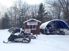
Frederic / Gaylord Area Trail Report – Sledheads of Frederic – 01/15
Not a flake of new snow overnight and there is a misty drizzle in the air. Maybe 1 to 3 coming overnight. I will believe that when I see it.
The only positive thing is the weather is showing snow every day for the next week but most of it lake effect. I would pretty much chalk up this MLK weekend as a junk weekend. If you happen to come up anyways stop by here to make sure I am awake. I can feel a boring weekend coming on.
Today’s pics are of the places that have tents and outdoor seating if you want to go that route. Everyone has take out too. Maybe we will get a winter surprise but don’t hold your breath. So many calls from people that want tor ride but cant. Thanks for checking in. Pete
<>
Visit Sledheads of Frederic on Facebook >>>>
<>
Postings From Regional Pages On Facebook

GAYLORD AREA UPDATE via Heart Lake Resort Cottages - Gaylord, MI >> Walkin’ in a winter wonderland🤍 #gaylord #snowphotos

FREDERIC - GAYLORD AREA UPDATE via Sledheads of Frederic , Michigan Snowmobiling >> STAY OFF THE ICE & LAKES Once again 2 more sledders fell thru and drowned. That makes 4 this season, the first 2 were just walking on the ice and went thru and these next 2 were riding. Please be aware of where you are at. We had about 2 inches of new fluffy overnight again. Riders that were in yesterday were having a good time and the snow is holding pretty good. Lets see how this week goes. They are callilng for warmer temps later in the week. Thanks for checking in. Pete... #gaylord
frederic-mi.com
STAY OFF THE ICE & LAKES Once again 2 more sledders fell thru and drowned. That makes 4 this season, the first 2 were just walking on the ice and went thru and these next 2 were riding. Please… WEATHER UPDATE via US National Weather Service Gaylord Michigan >> Lake effect snow showers continue today, heaviest near and south of Grand Traverse Bay. While snow showers gradually diminish through the evening, a clipper system is set to cross the area late tonight into Monday with additional widespread snow. #miweather #gaylord #cadillac #benzie #traversecity #petoskey #soo #newberryLake effect snow showers continue today, heaviest near and south of Grand Traverse Bay. While snow showers gradually diminish through the evening, a clipper system is set to cross the area late tonight into Monday with additional widespread snow.
WEATHER UPDATE via US National Weather Service Gaylord Michigan >> Lake effect snow continues tonight into Sunday as winds shift more northwesterly, shifting focus of snows with time. In addition to the snow, very cold wind chills and air temperatures are expected tonight, particularly in areas away from lake effect snowfall. #miweather #gaylord #cadillac #benzie #traversecity #petoskey
WOLVERINE - GAYLORD AREA UPDATE via The Thirsty Sturgeon >> 8 inches of Freshy Fresh this morning…Lookin’ great out there!! #gaylord #snowphotos
WEATHER UPDATE via US National Weather Service Gaylord Michigan >> Accumulating lake effect snow continues across northern Michigan today into Sunday. Gusty winds will lead to blowing and drifting snow, leading to quick drops in visibility – especially across open areas. Wind chills look to stay below zero today into tonight. Cold temperatures may also lead to freezing of wet roads this morning, contributing to potentially hazardous travel conditions for the first half of the weekend. #miweather #gaylord #cadillac #benzie #traversecity #petoskeyAccumulating lake effect snow continues across northern Michigan today into Sunday. Gusty winds will lead to blowing and drifting snow, leading to quick drops in visibility – especially across open areas. Wind chills look to stay below zero today into tonight. Cold temperatures may also lead to freezing of wet roads this morning, contributing to potentially hazardous travel conditions for the first half of the weekend.
FREDERIC - GAYLORD AREA UPDATE via Sledheads of Frederic , Michigan Snowmobiling >> Friday riders were out but certainly no big crowds, light sled traffic. I see 6 sleds over at the swamp right now and am sure they are there for the breakfast buffet. My gut feeling is its gonna be a slow saturday but conditions are still better than we have seen in years. Had dinner at the Frederic Inn last night and 3 of us had the prime rib and it was great as usual. Left overs for lunch today. Pics below are all from yesterday and last night. Thanks for checking in. Pete #gaylord #snowphotos
Light lake effect overnight, about 1 inch of new fluff
frederic-mi.com
Friday riders were out but certainly no big crowds, light sled traffic. I see 6 sleds over at the swamp right now and am sure they are there for the breakfast buffet. My gut feeling is its gonna be… WEATHER UPDATE via US National Weather Service Gaylord Michigan >> Accumulating snow returns to the Northwoods later this afternoon into Saturday as a cold front swings across the area, ushering in a much colder air mass for the weekend. Several inches of snow is expected across parts of northwest lower and the eastern U.P. by Saturday morning with additional lake effect snow continuing through Saturday. Below zero wind chills are expected for most areas late tonight through Saturday. Wind gusts of 25-35+ mph will lead to patchy blowing/drifting snow, especially across open areas. Quickly dropping temps tonight may freeze wet roads by Saturday morning. Combination of snow, winds, and temperatures will lead to hazardous travel conditions across parts of the area through Saturday morning. #miweather #gaylord #cadillac #benzie #traversecity #petoskeyAccumulating snow returns to the Northwoods later this afternoon into Saturday as a cold front swings across the area, ushering in a much colder air mass for the weekend. Several inches of snow is expected across parts of northwest lower and the eastern U.P. by Saturday morning with additional lake effect snow continuing through Saturday. Below zero wind chills are expected for most areas late tonight through Saturday. Wind gusts of 25-35+ mph will lead to patchy blowing/drifting snow, especially across open areas. Quickly dropping temps tonight may freeze wet roads by Saturday morning. Combination of snow, winds, and temperatures will lead to hazardous travel conditions across parts of the area through Saturday morning.
Load more
GAYLORD AREA UPDATE via Heart Lake Resort Cottages - Gaylord, MI >> Walkin’ in a winter wonderland🤍 #gaylord #snowphotos
FREDERIC - GAYLORD AREA UPDATE via Sledheads of Frederic , Michigan Snowmobiling >> STAY OFF THE ICE & LAKES Once again 2 more sledders fell thru and drowned. That makes 4 this season, the first 2 were just walking on the ice and went thru and these next 2 were riding. Please be aware of where you are at. We had about 2 inches of new fluffy overnight again. Riders that were in yesterday were having a good time and the snow is holding pretty good. Lets see how this week goes. They are callilng for warmer temps later in the week. Thanks for checking in. Pete... #gaylord
frederic-mi.com
STAY OFF THE ICE & LAKES Once again 2 more sledders fell thru and drowned. That makes 4 this season, the first 2 were just walking on the ice and went thru and these next 2 were riding. Please…WEATHER UPDATE via US National Weather Service Gaylord Michigan >> Lake effect snow showers continue today, heaviest near and south of Grand Traverse Bay. While snow showers gradually diminish through the evening, a clipper system is set to cross the area late tonight into Monday with additional widespread snow. #miweather #gaylord #cadillac #benzie #traversecity #petoskey #soo #newberryLake effect snow showers continue today, heaviest near and south of Grand Traverse Bay. While snow showers gradually diminish through the evening, a clipper system is set to cross the area late tonight into Monday with additional widespread snow.
WEATHER UPDATE via US National Weather Service Gaylord Michigan >> Lake effect snow continues tonight into Sunday as winds shift more northwesterly, shifting focus of snows with time. In addition to the snow, very cold wind chills and air temperatures are expected tonight, particularly in areas away from lake effect snowfall. #miweather #gaylord #cadillac #benzie #traversecity #petoskey
WOLVERINE - GAYLORD AREA UPDATE via The Thirsty Sturgeon >> 8 inches of Freshy Fresh this morning…Lookin’ great out there!! #gaylord #snowphotos
WEATHER UPDATE via US National Weather Service Gaylord Michigan >> Accumulating lake effect snow continues across northern Michigan today into Sunday. Gusty winds will lead to blowing and drifting snow, leading to quick drops in visibility – especially across open areas. Wind chills look to stay below zero today into tonight. Cold temperatures may also lead to freezing of wet roads this morning, contributing to potentially hazardous travel conditions for the first half of the weekend. #miweather #gaylord #cadillac #benzie #traversecity #petoskeyAccumulating lake effect snow continues across northern Michigan today into Sunday. Gusty winds will lead to blowing and drifting snow, leading to quick drops in visibility – especially across open areas. Wind chills look to stay below zero today into tonight. Cold temperatures may also lead to freezing of wet roads this morning, contributing to potentially hazardous travel conditions for the first half of the weekend.
FREDERIC - GAYLORD AREA UPDATE via Sledheads of Frederic , Michigan Snowmobiling >> Friday riders were out but certainly no big crowds, light sled traffic. I see 6 sleds over at the swamp right now and am sure they are there for the breakfast buffet. My gut feeling is its gonna be a slow saturday but conditions are still better than we have seen in years. Had dinner at the Frederic Inn last night and 3 of us had the prime rib and it was great as usual. Left overs for lunch today. Pics below are all from yesterday and last night. Thanks for checking in. Pete #gaylord #snowphotos
Light lake effect overnight, about 1 inch of new fluff
frederic-mi.com
Friday riders were out but certainly no big crowds, light sled traffic. I see 6 sleds over at the swamp right now and am sure they are there for the breakfast buffet. My gut feeling is its gonna be…WEATHER UPDATE via US National Weather Service Gaylord Michigan >> Accumulating snow returns to the Northwoods later this afternoon into Saturday as a cold front swings across the area, ushering in a much colder air mass for the weekend. Several inches of snow is expected across parts of northwest lower and the eastern U.P. by Saturday morning with additional lake effect snow continuing through Saturday. Below zero wind chills are expected for most areas late tonight through Saturday. Wind gusts of 25-35+ mph will lead to patchy blowing/drifting snow, especially across open areas. Quickly dropping temps tonight may freeze wet roads by Saturday morning. Combination of snow, winds, and temperatures will lead to hazardous travel conditions across parts of the area through Saturday morning. #miweather #gaylord #cadillac #benzie #traversecity #petoskeyAccumulating snow returns to the Northwoods later this afternoon into Saturday as a cold front swings across the area, ushering in a much colder air mass for the weekend. Several inches of snow is expected across parts of northwest lower and the eastern U.P. by Saturday morning with additional lake effect snow continuing through Saturday. Below zero wind chills are expected for most areas late tonight through Saturday. Wind gusts of 25-35+ mph will lead to patchy blowing/drifting snow, especially across open areas. Quickly dropping temps tonight may freeze wet roads by Saturday morning. Combination of snow, winds, and temperatures will lead to hazardous travel conditions across parts of the area through Saturday morning.
<>
Latest Trail Reports – Quick Links
- Petoskey Area Trail Report – 12/15
- Harbor Springs Area Trail Report – 12/15
- Cadillac Area Trail Report – 12/15
- Ironwood – Western U.P. Trail Report – 12/15
- Sault Ste. Marie Area Trail Report – 12/15
- Newberry Area Trail Report – 12/15
- Gaylord Area Trail Report – 12/15
- Frederic / Gaylord Area Trail Report – Sledheads of Frederic – 12/15
- Traverse City Area Trail Report – 12/14
- Lake Gogebic Area Trail Report – 12/14
- Keweenaw Peninsula Trail Report – 12/14
- Petoskey Area Trail Report – 12/14
- Paradise Area Trail Report – 12/14
- Baldwin Area Trail Report – 12/14
- Sault Ste. Marie Area Trail Report – 12/14
- Grand Marais Area Trail Report – 12/13
- Lake Gogebic Area Trail Report – 12/13
- Newberry Area Trail Report – 12/13
- Cadillac Area Trail Report – 12/13
- Drummond Island Trail Report – 12/13
- Gaylord Area Trail Report – 12/13
- Frederic / Gaylord Area Trail Report – Sledheads of Frederic – 12/13
- Ontonagon Area Trail Report – 12/13
- Harbor Springs Area Trail Report – 12/13
- Seney Area Trail Report – 12/12
- Traverse City Area Trail Report – 12/12
- St. Helen – Roscommon Trail Report – 12/12
- Ontonagon Area Trail Report – 12/12
<>