Michigan Trail Report

Trail Reports


Frederic / Gaylord Area Trail Report – Sledheads of Frederic – 12/29

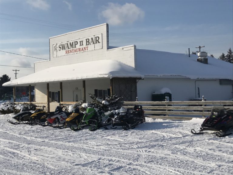
Still nice and cold at 15 degrees at noon in Frederic and more sunny than I would like to see. Sleds are out and about all over. I was in Frederic at 7:30 this morning and there was no new snow over night. I had to go up to Alba this morning to show a house up there, I drove thru lakes of the north and the snow around Alba was a winter wonderland. It looked like 18 inches where I saw fresh sled tracks. From there I headed down to Kalkaska where it was busy with sleds all the way down to there. Snow looked good but of course that was north and west of Frederic. I only wish we could have that same amount of snow here. Groomers are out and about in all areas. The pics below I took yesterday but the pics at the swamp and the gas station are from this morning. I had a cancelation for my cottage this morning so we are still available for this weekend if you want a nice place to stay and ride from. We are right near Camp Grayling by Lake Margrethe….call if you are interested. Thanks for checking in. Pete

<>

Visit Sledheads of Frederic Website >>>>

<>

Postings From Regional Pages On Facebook

Comments Box SVG iconsUsed for the like, share, comment, and reaction icons

This message is only visible to site admins
Problem displaying Facebook posts.

PPCA Error: Due to Facebook API changes it is no longer possible to display a feed from a Facebook Page you are not an admin of. The Facebook feed below is not using a valid Access Token for this Facebook page and so has stopped updating.

<>

Visit Sledheads of Frederic Website >>>>

<>

Latest Trail Reports – Quick Links

<>

December 29, 2017 | Uncategorized

Keweenaw Peninsula Trail Report – 12/29

As of 12/29/17, the Keweenaw Peninsula has 23″ of snow on the ground and has received a total of 119″ of snow for the season.
Keweenaw Snowmobile Trails-Provided by the Keweenaw Snowmobile Club

Snowmobile trails from Twin Lakes to Copper Harbor are open and in fair condition. Some groomers are out.

Any trail usage should still be done with caution as there is still some low snow cover and wet areas.

Trail 124 and 133 are temporarily closed for logging. You can take Trail 122 to get to Gay.

Remember when you’re out on the trails to watch out for the groomers. They have the right away.

<>

Visit Keweenaw Convention & Visitors Bureau Website >>>>

<>

Latest Postings On Facebook

Comments Box SVG iconsUsed for the like, share, comment, and reaction icons

Tuesday December 23rd, 2025 - 8:30 am

Michigan Snowmobile Trail Report

WEATHER UPDATE via US National Weather Service Marquette Michigan >> A cold front will push through this afternoon and evening bringing gusty northwest wind of 25-35 mph near Lake Superior and over the Keweenaw. Otherwise low chances for snow and or sleet are forecast for Christmas Eve and Christmas Day (10-30% chance). #miweather #keweenaw #westernup #marquette #munising #seney #newberry #soo #straitsareaA cold front will push through this afternoon and evening bringing gusty northwest wind of 25-35 mph near Lake Superior and over the Keweenaw. Otherwise low chances for snow and or sleet are forecast for Christmas Eve and Christmas Day (10-30% chance). ... See MoreSee Less

WEATHER UPDATE via US National Weather Service Marquette Michigan >> A cold front will push through this afternoon and evening bringing gusty northwest wind of 25-35 mph near Lake Superior and over the Keweenaw. Otherwise low chances for snow and or sleet are forecast for Christmas Eve and Christmas Day (10-30% chance). #miweather #keweenaw #westernup #marquette #munising #seney #newberry #soo #straitsarea

Monday December 22nd, 2025 - 12:01 pm

Michigan Snowmobile Trail Report

WEATHER UPDATE via US National Weather Service Marquette Michigan >> It will be warmer today with highs in the upper 20s to mid 30s. Light snow is possible south of an Iron Mountain to Escanaba line but any accumulation will be very light. There is a chance (20-30%) for light snow across the central and eastern U.P tonight but little in the way of accumulation is expected. #miweather #keweenaw #westernup #marquette #munising #seney #newberry #soo #straitsareaIt will be warmer today with highs in the upper 20s to mid 30s. Light snow is possible south of an Iron Mountain to Escanaba line but any accumulation will be very light. There is a chance (20-30%) for light snow across the central and eastern U.P tonight but little in the way of accumulation is expected. ... See MoreSee Less

WEATHER UPDATE via US National Weather Service Marquette Michigan >> It will be warmer today with highs in the upper 20s to mid 30s.  Light snow is possible south of an Iron Mountain to Escanaba line but any accumulation will be very light.  There is a chance (20-30%) for light snow across the central and eastern U.P tonight but little in the way of accumulation is expected. #miweather #keweenaw #westernup #marquette #munising #seney #newberry #soo #straitsarea

Sunday December 21st, 2025 - 1:08 pm

Michigan Snowmobile Trail Report

WEATHER UPDATE via US National Weather Service Marquette Michigan >> Lake effect snow showers will continue in the northwest wind snowbelts this morning and then begin to shift north and offshore this afternoon into the evening as winds become southwesterly. Additional snowfall of up to an inch in the west and 1 to 3 inches in the east can be expected. A round of light snow is possible on Monday into Monday night with temperatures moderating through mid-week. #miweather #keweenaw #westernup #marquette #munising #seney #newberry #soo #straitsareaLake effect snow showers will continue in the northwest wind snowbelts this morning and then begin to shift north and offshore this afternoon into the evening as winds become southwesterly. Additional snowfall of up to an inch in the west and 1 to 3 inches in the east can be expected. A round of light snow is possible on Monday into Monday night with temperatures moderating through mid-week. ... See MoreSee Less

WEATHER UPDATE via US National Weather Service Marquette Michigan >> Lake effect snow showers will continue in the northwest wind snowbelts this morning and then begin to shift north and offshore this afternoon into the evening as winds become southwesterly.  Additional snowfall of up to an inch in the west and 1 to 3 inches in the east can be expected.  A round of light snow is possible on Monday into Monday night with temperatures moderating through mid-week. #miweather #keweenaw #westernup #marquette #munising #seney #newberry #soo #straitsarea

Saturday December 20th, 2025 - 12:22 pm

Michigan Snowmobile Trail Report

WEATHER UPDATE via Michigan Storm Chasers >> Here is our last call for ongoing system snow and lake effect snow from now through Sunday evening at 6 pm EST, December 20th & 21st, 2025.
Uncertainty exists primarily in our trace-1" category which extends from Frankfort and Alpena south to I-96/I-69. The clipper moving through today may produce a quick squall of rain & snow with minimal accumulation some time beyond 1 pm EST, but models haven't determined if this band will solidify or not. If it does, the chance for a rain/snow mix exists in areas highlighted in the pink dashed box. This rain/snow mix would only be today. Any snow on Sunday will be lake effect off of Lake Superior, hence why our highest totals of 4-8" are located east of Munising over to Paradise. Not too impactful of a system in terms of Michigander standards, but do take it slow if you encounter any snow squalls and/or visibly slick roads. #miweather #keweenaw #westernup #marquette #munising #seney #newberry #soo #straitsarea #gaylord #cadillac #benzie #traversecity #petoskeyHere is our last call for ongoing system snow and lake effect snow from now through Sunday evening at 6 pm EST, December 20th & 21st, 2025.

Uncertainty exists primarily in our trace-1" category which extends from Frankfort and Alpena south to I-96/I-69. The clipper moving through today may produce a quick squall of rain & snow with minimal accumulation some time beyond 1 pm EST, but models haven't determined if this band will solidify or not. If it does, the chance for a rain/snow mix exists in areas highlighted in the pink dashed box. This rain/snow mix would only be today. Any snow on Sunday will be lake effect off of Lake Superior, hence why our highest totals of 4-8" are located east of Munising over to Paradise. Not too impactful of a system in terms of Michigander standards, but do take it slow if you encounter any snow squalls and/or visibly slick roads.

-- Trusted Partner of the Day --
A-Class Construction & Restoration | 833-298-ROOF is the number to call for all home construction needs across northwestern lower Michigan!
... See MoreSee Less

WEATHER UPDATE via Michigan Storm Chasers >> Here is our last call for ongoing system snow and lake effect snow from now through Sunday evening at 6 pm EST, December 20th & 21st, 2025.
Uncertainty exists primarily in our trace-1 category which extends from Frankfort and Alpena south to I-96/I-69. The clipper moving through today may produce a quick squall of rain & snow with minimal accumulation some time beyond 1 pm EST, but models havent determined if this band will solidify or not. If it does, the chance for a rain/snow mix exists in areas highlighted in the pink dashed box. This rain/snow mix would only be today. Any snow on Sunday will be lake effect off of Lake Superior, hence why our highest totals of 4-8 are located east of Munising over to Paradise. Not too impactful of a system in terms of Michigander standards, but do take it slow if you encounter any snow squalls and/or visibly slick roads. #miweather #keweenaw #westernup #marquette #munising #seney #newberry #soo #straitsarea #gaylord #cadillac #benzie #traversecity #petoskey

Comment on Facebook

A snow squall. Maybe that’s what we had going on in Wakefield today. It was nuts!

Saturday December 20th, 2025 - 12:08 pm

Michigan Snowmobile Trail Report

WEATHER UPDATE via US National Weather Service Marquette Michigan >> The first round of snow continues through mid-morning before most get a brief dry period into this afternoon; snow showers persist in the Keweenaw. Then a transition over to lake effect snow over the west to northwest wind snowbelts. 3 to 7 inches of snowfall over the east tonight into Sunday morning.
Windy conditions are expected this afternoon into tonight behind a cold front. Widespread westerly wind gusts are expected between 25 to 35 mph; up to 45 mph near Lake Superior and in the Keweenaw. #miweather #keweenaw #westernup #marquette #munising #seney #newberry #soo #straitsarea
... See MoreSee Less

WEATHER UPDATE via US National Weather Service Marquette Michigan >> The first round of snow continues through mid-morning before most get a brief dry period into this afternoon; snow showers persist in the Keweenaw. Then a transition over to lake effect snow over the west to northwest wind snowbelts. 3 to 7 inches of snowfall over the east tonight into Sunday morning.
Windy conditions are expected this afternoon into tonight behind a cold front. Widespread westerly wind gusts are expected between 25 to 35 mph; up to 45 mph near Lake Superior and in the Keweenaw. #miweather #keweenaw #westernup #marquette #munising #seney #newberry #soo #straitsareaImage attachment

Saturday December 20th, 2025 - 12:01 pm

Michigan Snowmobile Trail Report

KEWEENAW PENINSULA UPDATE via Western UP Trail Reports >> 20 December 2025
I've lost the ol Merc again. We added another 5 inches last night putting us at a total for the season at 76 inches and 20 inches on the ground.
☠️ Stretch
Western UP Trail Reports Web Cam
video.nest.com/live/4BKmS6XRiT #keweenaw #snowphotos20 December 2025
I've lost the ol Merc again. We added another 5 inches last night putting us at a total for the season at 76 inches and 20 inches on the ground.
☠️ Stretch

Western UP Trail Reports Web Cam
video.nest.com/live/4BKmS6XRiT
... See MoreSee Less

KEWEENAW PENINSULA UPDATE via Western UP Trail Reports >> 20 December 2025
Ive lost the ol Merc again. We added another 5 inches last night putting us at a total for the season at 76 inches and 20 inches on the ground.
☠️ Stretch 
Western UP Trail Reports Web Cam 
https://video.nest.com/live/4BKmS6XRiT #keweenaw #snowphotos

Saturday December 20th, 2025 - 11:37 am

Michigan Snowmobile Trail Report

KEWEENAW PENINSULA UPDATE via The U.P. Superior Snowmobile Club >> Groomer Brad reporting:
Trail 3 from Twin Lakes to Mass City is in very good condition. There are a few wet areas that he filled and should have frozen overnight. The DNR funded a new drag for us this year. Brad reports that it is a very nice tool! 🙂
Thanks Brad for the update! #keweenaw
... See MoreSee Less

Saturday December 20th, 2025 - 3:31 am

Michigan Snowmobile Trail Report

WEATHER UPDATE via US National Weather Service Marquette Michigan >> Another system brings a quick round of light to moderate snowfall late tonight into early Saturday. A widespread 1-3 inches of snow is expected, possibly locally higher up to 3-4in in the eastern UP. A change over to lake effect snow is expected in the NW wind snow belts Saturday afternoon, lingering into Sunday. Winds turn gusty for Saturday, with gusts as high as 40-45mph possible over the Keweenaw, where a Wind Advisory is in effect Saturday afternoon and evening. #miweather #keweenaw #westernup #marquette #munising #seney #newberry #soo #straitsareaAnother system brings a quick round of light to moderate snowfall late tonight into early Saturday. A widespread 1-3 inches of snow is expected, possibly locally higher up to 3-4in in the eastern UP. A change over to lake effect snow is expected in the NW wind snow belts Saturday afternoon, lingering into Sunday. Winds turn gusty for Saturday, with gusts as high as 40-45mph possible over the Keweenaw, where a Wind Advisory is in effect Saturday afternoon and evening. ... See MoreSee Less

WEATHER UPDATE via US National Weather Service Marquette Michigan >> Another system brings a quick round of light to moderate snowfall late tonight into early Saturday. A widespread 1-3 inches of snow is expected, possibly locally higher up to 3-4in in the eastern UP. A change over to lake effect snow is expected in the NW wind snow belts Saturday afternoon, lingering into Sunday. Winds turn gusty for Saturday, with gusts as high as 40-45mph possible over the Keweenaw, where a Wind Advisory is in effect Saturday afternoon and evening. #miweather #keweenaw #westernup #marquette #munising #seney #newberry #soo #straitsarea

Saturday December 20th, 2025 - 3:20 am

Michigan Snowmobile Trail Report

KEWEENAW PENINSULA UPDATE via The U.P. Superior Snowmobile Club >> Trail 109 South of Silver Mountain is ready to be ridden! Thanks to Barb from Baraga Tourism for allowing Superior Snowmobile Club to take over this stretch of trail. Many thanks to Jon, Kurt, Todd, and Joyce for for getting this done! You all rock!
Happy Trails!! #keweenaw #snowphotos
... See MoreSee Less

Load more

<>

Postings From Regional Pages On Facebook

Comments Box SVG iconsUsed for the like, share, comment, and reaction icons
Load more

<>

Visit TheKeweenaw.com Website >>>>

<>

Latest Trail Reports – Quick Links

<>

December 29, 2017 | Uncategorized
Northern Michigan Snowmobile - Snowmobiling in Northern Michigan and the Upper Peninsula - produced by North Guide Internet.